Kingston, South Australia

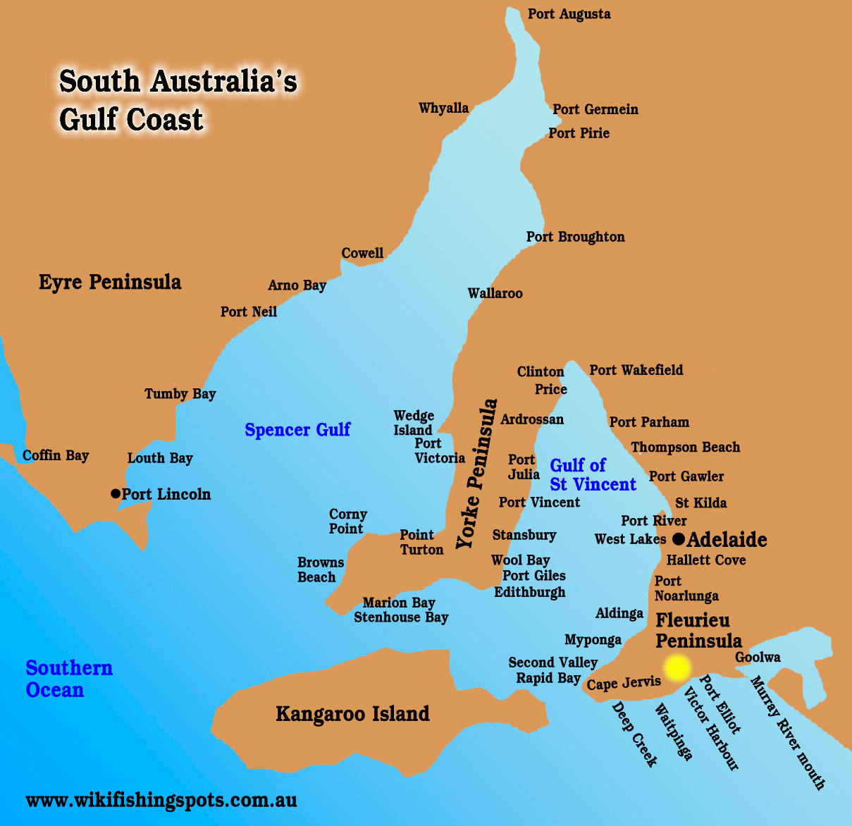
Kingston is one of South Australia’s crayfish capitals, home of the “big lobster”.

There are plenty of other fish to catch.

The town has sheltered boat launching, an excellent fishing jetty, and rock walls.

Maria Creek has black bream, juvenile salmon and mullet.

For boaters, the local weedbeds have whiting, mullet, garfish, flathead and squid.

Flounder spearing at night is popular on the sheltered beaches. A waterproof light such as this is helpful if you plan to give floundering a try.

The jetty produces scores of tommy ruff and squid, along with mullet and occasional mulloway.

Boats can be launched from the beach by 4WD through to Granite Rocks 19km north of Kingston on Long Beach.

Nation Rock lies about 3km off Long Beach 17km north of Kingston (see GPS), but it can break unexpectedly.

Long Beach becomes deep north of Granite Rocks and fishermen looking for mulloway concentrate on this section.

Drive along the beach track and look for likely gutters.

Travel with two vehicles because of soft sand patches.

Long Beach can have piled weed and is fully exposed to the Southern Ocean.

Mulloway are the main target, but salmon, snapper, gummy sharks, school sharks and flathead are caught.

The beach north of Tee Tree Crossing is closed to vehicles from October 24 to December 24. Camping is in marked areas.

Beach cockles are available.

A sanctuary exists along the beach between latitudes 36 10.094S and 36 10.094S.

South of Kingston, great fishing is had at the tiny holiday town of Cape Jaffa.

Kingston Fishing GPS Marks

Nation Rock 36 40.912S 139 49.542E
Granite Rocks 36 39.536S 139 51.068E

Here is the SA seasonal fishing calendar for various fish species.

Book your fishing stay early at Booking.com

Kingston weather and tides
SA boat ramps
SA fishing regulations
SA marine parks

NOTE: Special snapper rules apply in South Australia – more info here.

Email corrections, additions, pictures or video here.

Victor Harbour, South Australia

Victor Harbour, South Australia

Victor Harbour is a hugely popular weekend destination for Adelaide fishermen.

Being outside the shelter of the Gulf of St Vincent, the rugged coastline between “Victor” and Cape Jervis has deeper beaches and rock platforms that tend to produce bigger fish than the shallower gulf beaches.

Victor Harbour has a sheltered boat ramp, but the ocean outside must be treated with respect.

The area inside Granite Island is a useful anchorage largely protected from ocean swell.

Granite Island is the main attraction for landbased fishos. It is accessed on foot via a long causeway over shallow weedbeds.

It is quite a walk over the causeway and to the popular Screwpile Jetty, so take a trolley if you fish with a lot of gear.

The Screwpile Jetty is short but borders deep water and produces salmon, snapper, seven-gill sharks, barracouta, mulloway, silver trevally and gummy sharks, as well as tommy ruff, sweep and chow.

The jetty runs hot or cold but the chance of quality fish keeps fishos coming back.

Snapper and mulloway bite best at dusk and dawn.

Near the Screwpile Jetty is an ocean rock wall that shields the jetty.

This rock wall produces just about anything, including some cracker sweep, but should not be fished in a swell as waves can break over the top.

The island’s causeway is good for gar and squid.

Boaters will find squid, gar, tommy ruff, KG whiting, salmon, snapper, leatherjackets and snook on shallow reefs and over seagrass around Victor Harbour.

Boaters who want to fish inshore for mixed species should try grounds between Granite Island and Wright Island.

Bluefin tuna are reliable in season and are targeted in canoes by adventurous fishos.

Nearby, Rosetta Head (The Bluff) has a small jetty that is popular with squid fishos.

Victor Harbour beaches fish well for mullet in autumn/winter, with salmon trout all year, and occasional big mulloway.

Port Elliot’s small jetty has produced big mulloway.

See the region’s beaches here.

Victor Harbour’s Hindmarsh and Inman Rivers usually have black bream, with redfin and carp upstream.

Use an unweighted or very lightly weighted bait of peeled prawn in the rivers for bream.

Trout occur in the upper Hindmarsh River, with good fly fishing in years past, but access is difficult.

The short section of the Hindmarsh from the second waterfall down to the gauging weir was historically stocked with trout.

Prawns, squid and cockles (pipis) are all good baits for general saltwater fishing around Victor Harbour.

Mince meat is often used for yelloweye mullet.

Be sure to take some squid jigs to Victor Harbour. Squid almost always are best at dawn and dusk, and at night.

Off the surf beaches, any surf rod that can cast a chrome-slice lure a reasonable distance will catch salmon trout, which are usually about. They also respond to most types of bait.

A live salmon trout or mullet makes a great bait for mulloway, look for a deep gutter and fish a large high tide, with night fishing most likely to succeed.

Because of its popularity with Adelaide folk as a seaside destination, accommodation over holiday periods tends to book out early.


Booking.com

Here is the SA seasonal fishing calendar for various fish species.

Book your fishing stay early at Booking.com

Victor Harbour weather and tides
Victor Harbour coastline
Victor Harbour accommodation
SA fishing regulations
SA marine parks
Return to SA Fishing Map

NOTE: Special snapper rules apply in South Australia – more info here.

Email corrections, additions, pictures or video here.

Fishing the Savannah Way

The eastern Top End is an exciting region for touring fishos, being far from population centres and therefore receiving less fishing pressure.

The habitat is first class, but fishing quality changes markedly with the seasons, depending on wet season rainfall.

Adventurous fishos who explore the coast in a boat will find tidal creeks that hardly see a lure or bait.

Most who visit here only fish the rivers and creeks, so the shallow reefs along the coast are hardly fished.

The eastern Top End has some of the Northern Territory’s great barramundi rivers, such the Roper, Limmen and McArthur.

The central feature of this area for travellers is Limmen National Park, declared in July 2012.

There are several camping areas within the park. Munbililla (also called Tomato Island) is the most important for fishermen.

Limmen Bight Fishing Camp and Lorella Springs Wilderness Park on Rosie Creek are located outside the national park.

Boat launch sites are at Roper Bar, Munbililla, Port Roper, Towns River, Limmen Bight Fishing Camp, Rosie Creek, Robinson River, Mule Creek and McArthur River.

Visitors can drive in from the north or south, but the roads are subject to closure from annual wet season flooding, and are often corrugated.

Call Parks and Wildlife in Katherine (08 8973 8888) or Nathan River Ranger Station (08 8975 9940) for road info, and Katherine Rod and Rifle (08 8972 1020) for the latest fishing info.

Munbililla (Tomato Island) campground on the Roper, opened in 2013. This used to be just a clearing in the bush near the concrete boat ramp, but it became so popular a proper campground was needed. It has ablution facilities and a ranger station.

Port Roper, at the river mouth on the south bank, has a concrete ramp and cleared space in the bush nearby that is used for camping. This is a “roughing it location” but huge barramundi, groper, salmon and jewfish are caught.

Small tides are best at the Roper mouth, which are difficult to determine as the river has sometimes unpredictable tides because of quirks of the shallow Gulf of Carpentaria.

South of the Roper is the smaller Towns River, which has camping near the riverbank, with an associated ablution block.

The Towns has good barra fishing and crabbing, but the fish are on average smaller than Roper fish.

South again is the Limmen Bight River, which offers a bush camping experience along the river banks at Steve Barrett’s private fishing camp.

The campsites are unimproved, next to tidal water, and boats can be moored nearby, but they will dry out at low tide.

Fish the Limmen on reasonably large tides.

Being sandy, it is quite clear, and even the last creek at the mouth can have several feet of water clarity unless the wind stirs it up.

Small tides are not always ideal for chasing barramundi, with the exception being in rivers with turbid waters.

Centre Island tides provide approximate tide times to plan your Limmen River trip.

Mining traffic diminished with the closure of local mines in 2014 after a commodity slump, but there are still heavy vehicles using the highway.

Visitors must take most supplies in.

Fuel is at Borroloola, Hells Gate, Robinson River community and King Ash Bay (McArthur River). Roper Bar store was closed at publication of this post but nearby Urupunga store sells to the public.

The Limmen camp supplied fuel in jerry cans at our last inquiry.

Tank water is at the Limmen camp only if there has been enough rain. Call first.

Keep in mind that the road is closed each year for the wet season. The roads are rough and can break trailers.

Back to the NSW/ACT Fishing Map
Back to the NT Fishing Map
Back to the Queensland Fishing Map
Back to the SA Fishing Map
Back to the Tasmanian Fishing Map
Back to the Victorian Fishing Map
Back to the WA Fishing Map

Email corrections, additions, pictures or video here.

Book your fishing B&B early at Booking.com


Buy Redback on eBay