Constant Creek, Queensland

Constant Creek fishing spots - see the text
Constant Creek fishing spots – see text for the key

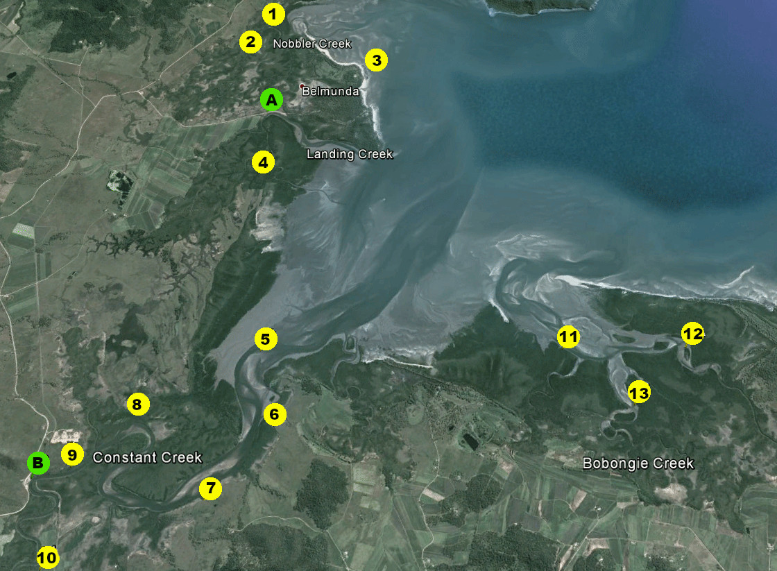
Constant Creek fishing map

Fishing spots
1. Deep water along the bend of this small creek can hold surprisngly good fish. Use livebait of mullet or herring for barramundi and mangrove jacks . Salmon, whiting and flathead are caught along the sandspit at the mouth.
2. Grunter, mangrove jacks and barramundi are caught upstream in Nobbler Creek.
3. whiting, flathead and salmon along the beach at hight itde, best on bigger tides.
4. This small creek has a well defined channel. Worth a look for most local species and mud crabs, try trolling the entrance channel at half tide.
5. flathead along channel edges. whiting on a rising tide. Look for salmon feeding over flats on rising tide.
6. One of the better deepwater spots for barramundi, mangrove jacks , salmon and grunter.
7. Troll the deep bank.
8. Deep bend, livebait works well for most species, including grunter.
9. Trolling area for most species.
10. Barramundi, mangrove jacks , cod and bream on the deep bends.
11. Barramundi and salmon here on a dropping tide.
12. Holes here hold can fish well towards low tide.
13. Good crabbing creek. Be sure to secure pots on bigger tides.

Boat ramps
A – Constant Creek sealed boat ramp.
B – Landing Creek sealed boat ramp.

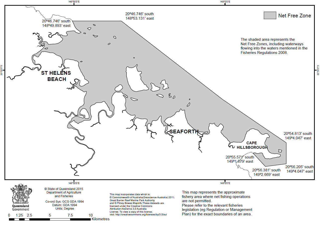
Belmunda holiday community is located just south of the Cape Hillsborough net-free zone, and has several good creeks nearby, the most popular fishing area being Constant Creek and its associated bay.

Landing Creek and Bobongie Creek are also productive large systems.

Smaller creeks such as Nobbler Creek are worth a look on the biggest tides.

This area is shallow and affected by huge tides, with much of the flats area drying at low tide.

Launching and navigating is easier and safer towards high tide.

Most local fishos launch at high tide, and fish the low and incoming tide, and return to the ramp on the high.

During larger tides it becomes rough when wind and tide are opposed, especially around points.

The water clears during the smaller neap tides. Fish with lures just after dead neaps as the tidal cycle begins to pick up, while the water is still clear.

During bigger tides some areas are suited to tidal lock-in fishing, leaving the boat and walking the holes and channels, casting along the edges where the sand is firm enough to do so.

The tide can come in fast so don’t walk far from the boat.

Fishing fires up after a big summer wet season, with poor fishing in dry years.

The local beaches have flathead, whiting, threadfin and blue salmon, barramundi and bream.

Barramundi are best in warm weather, keeping in mind the Queensland annual closed season.

Deep water in Constant Creek, mainly on its upstream bends, holds barramundi, cod, mangrove jacks and grunter.

Fish tidal drains on an outgoing tide for barramundi and salmon.

Salmon and queenfish can be found along channel edges along the flats on a rising tide.

Work mangrove edges with shallow lures as the tide pushes in.

Bird Rock is a lone rock worth a quick troll at high tide for queenfish and trevally.

Cod, sweetlip. tuskfish (bluebone) and coral trout are within range of a 4m tinnie in good weather.

Mackerel, queenfish and trevally are caught on the inshore reefs by trolling and casting.

Mud crabs are usually about, with numbers varying each year. During big tides pots should be well secured or they will wash away, or at the least the floats will go under.

Nonetheless, big tides can produce plenty of crabs, with the action on the early push in.

Prawn runs are usually good in season, and yabbies (nippers) can be collected for bait on many of the flats.

Collecting yabbies is well worth the effort for the biggest whiting, with the really good fish taken at night by dedicated anglers.

There are launch sites at Constant Creek and Landing Creek.

Book your fishing stay early at Booking.com


fish finder book

Belmunda tides
QLD fishing regulations
QLD marine parks
Return to QLD fishing map

Email corrections, additions, pictures or video here.

Lake Burbury, Tasmania

A state government map of Lake Burbury

Lake Burbury is a large open-all-year impoundment near Tasmania’s West Coast.

Though about 20km long the lake is quite narrow for its length.

In most conditions there are usually places where boaters can fish out of the wind.

The lake has a huge bag limit because of the large number of fish available, which includes browns and rainbows.

The Inland Fisheries Service says it it one of the best angling destinations in Tasmania.

The A10 highway crosses the centre of Lake Burbury where access to the northern camping and launching areas is sign posted.

Access to the camping area and boat ramp at the southern end of Lake Burbury is through Queenstown on the Mt Jukes Road.

All access roads are sealed.

Lake Burbury is managed as a wild fishery.

The many spawning streams entering the lake ensure good natural recruitment, which is why the lake has a large bag limit.

Lake Burbury has great water level fluctuations and can fall dramatically during drought. During this time the shores are accessible to fish, when full landbased fishing is limited.

It is often productive when the weather is overcast or during rains.

Fishos enjoy superb windlane fishing at times.

In the morning a windlane can have many surface-feeding rainbow and brown trout, which usually take wet or dry flies or bait.

Large dry flies can be effective.

Like many of Tasmania western and southern freshwater fishing locations, the lake’s water is a dark tannin colour.

Nonetheless clarity is fine for lure and fly fishing.

An electric motor or drogue helps when windlane fishing.

Trolling around the edges usually finds good fish.

Swimming lures over submerged trees and snags along the shoreline is usually more productive than open-water trolling.

Keep an eye on the sounder and get lures down to the fish.

For bigger fish, cast soft plastic lures where rivers enter the lake, as well as off points, around timber, and over rock drop-offs.

Bounce soft plastic lures along the bottom for best results. A tackle-retriever is essential for inevitable snags.

The lake has a reputation for producing loads of smaller fish, but the bigger fish are there.

Book your fishing stay early at Booking.com

Tasmanian fishing regulations
Tasmanian marine reserves
Tasmanian saltwater fishing seasons
Trout fishing spot access programs
Fisheries assessment reports
Buy a freshwater fishing licence
Tasmanian lake levels (hydro)
Tasmanian river flows (govt)
Tasmanian lake webcams
Tasmanian river flows
Bag and size limits
Private Tasmanian trout fisheries
Return to the Tasmanian Fishing Map

Email updates or corrections to [email protected]

Brumbys Creek, Tasmania

Brumbys Creek provides some of Tasmania’s most consistent stream-based trout fishing.

The creek, located near Cressy, about a 40-minute drive from Launceston, is a lowland tailrace fishery.

The waterflow is controlled by hydro-electricity managers, who release water from Great Lake.

Three weir sections each provide slightly different fishing conditions.

Mainly brown trout are caught, along with some rainbows.

There are also Atlantic salmon, tench, eels and redfin.

The state government has negotiated access for fishermen across some of the associated private land.

Where signs are displayed fishermen have free access, but in other locations visitors must ask permission.

Brumbys is a wild trout fishery.

The creek is known for consistent mayfly hatches and visible tailing trout, with excellent sight-fishing when the fish are cruising weedbeds.

There are also fly fishing opportunities tempting dragonfly and caenid feeders, as well as good bait fishing and blind lure-casting.

Calm days are best, as the wind blows hard at times and can make fishing difficult, but do not be put off by rain.

Water quality varies but is usually good.

Because of the relatively steady water level insect hatches are not as substantial as other lowland fisheries but they are consistent through the season.

Warm, humid weather brings on red-spinner duns, with the best hatches in late spring and early summer, usually around dusk.

Smaller hatches continue through January and February.

The best dry fly fishing is usually on warm days at dusk.

Tailers run from August to January, and are arguably best in the top weir pondage in mornings and afternoons, and on overcast days.

Lure fishos usually do well on sunny days when the water is clear, casting the channel between the first and second weirs.

Bigger trout are often found in deeper water.

After heavy rain the creek can fish well down to its junction with the Macquarie. In these conditions fish run-offs and submerged shores.

There is not much timber in the creek so light tackle can be used.

Worms and wattle grubs work well for bait fishing, and casting unweighted drifting baits while on the move is the best way to find fish.

The weirs

The three weirs were built on Brumbys Creek in the 1960s to smooth flows from Poatina power station.

Above Weir 1 the creek is wide and shallow with some channels, with shallow shorelines, weed and some timber.

Weed growth here thickens throughout as summer progresses.

Access to this section is via Fisheries Lane, an unsealed road. Launching facilities are suited only to cartopper dinghies, inflatables and yaks.

Lure fishing current lines and dry fly fishing the east shore above the weir works well from a boat.

Weir 1 provides arguably the best fly fishing, with its relatively clear shoreline and weedy margins where fish feed early in the season, or when the weather warms.

Bait fishing is prohibited above the first weir.

Below Weir 1 is a wide area of shallow water with a mostly mud and weed bottom.

Soft plastics and surface lures can be fished here but weed can make lure fishing hard.

Trout congregate where the channel drops and this area can be fished all the way to the second weir.

Cast over the edge of flats and work lures down the channel drop offs.

Access along this stretch is limited by undergrowth.

The water widens as it approaches the second weir.

The road leads all the way to the second weir and from there are access signs.

Waders are useful when fishing the first and second weir sections.

Fishing from a boat is prohibited between the first and second weir.

The fast water below the second weir produces fish and is easily reached from the road.

Clear banks make easy fishing here almost all the way to the bottom weir.

Most fish in this section are smaller but the easy access makes it a popular area.

Much of the river below the second weir flows over shallow weed and can therefore be difficult to fish with lures.

There is good fly fishing along this section.

Below the third weir the creek eventually flows into the Macquarie River.

The banks are easily fished for a long section.

The fast water directly below the weir sometimes has escaped rainbow trout from a local fish farm.

The river between the third weir and Macquarie River has a main channel and weed growth. Fishing from a boat here is prohibited.

Strict boating rules apply at Brumbys, with different rules in each weir section.

Book your fishing stay early at Booking.com

Tasmanian fishing regulations
Tasmanian marine reserves
Tasmanian saltwater fishing seasons
Trout fishing spot access programs
Fisheries assessment reports
Buy a freshwater fishing licence
Tasmanian lake levels (hydro)
Tasmanian river flows (govt)
Tasmanian lake webcams
Tasmanian river flows
Bag and size limits
Private Tasmanian trout fisheries
Return to the Tasmanian Fishing Map

Email corrections, additions, pictures or video here.

Book your fishing B&B early at Booking.com


Buy Redback on eBay