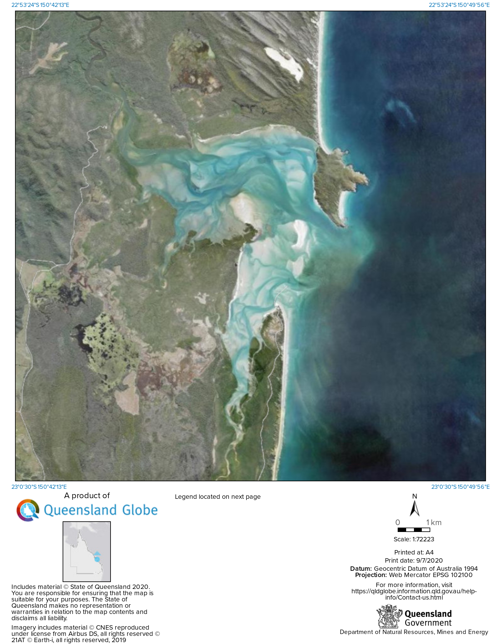
This broad, shallow and mostly sandy estuary 20km north of Yeppoon is the mutual mouth of Waterpark and Fishing Creeks.
The bay mostly dries at low tide, leaving shallow shifting channels, that finally run to sea past a rocky headland.
Careful trip planning and navigation is required.
Much of the bay is surrounded by national park, and the bay itself is part of the exciting Capricorn no-commercial-netting area proclaimed in 2015.
Outside the bay is excellent bluewater fishing, with the Keppels, Finlays, The Barge and Pinnacle producing good fish, and Karamea, Goodwin and the Douglas Shoals out wider for those with suitable boats.
Waterpark Creek has the two launch sites, with the upstream site at Corbetts Landing being sealed but with hazardous rocks located above and below in the creek.
Kellys Landing is further downstream but the road in is poor.
The creek upstream of Kellys Landing is closed to bait-netting, so bait must be collected in the bay for use in the creek.
Corio Bay has good yabbie banks and a broad spread of species. The most common are whiting, bream, flathead, barra, mangrove jacks , blue salmon, flounder and tarpon.
Tripletail are caught on occasion. Prawns are patchy.
There is a fair chance of picking up a barramundi in summer, a prospect that seems to have improved since net fishing was banned in the bay from 2018.
Barramundi are found in the low-tide holes and along rocky edges, or where baitfish gather.
The mouth of the inlet produces big jewfish on the turn of large tides.
Mud crabs are caught at times.
Corio Bay is famous for its whiting. In winter flathead can be prolific, and blue salmon schools provide furious action.
There are numerous fishable rockbars and holes above and below Corbetts Landing. The landing itself has a log wall which is a good land-based fishing spot.
Queenfish, trevally and mackerel are found near the bay’s entrance, with good grunter on any rough ground outside.
Waterpark Creek flows freshwater at the top.
Corio Bay’s Greenslopes and Sandfly Creek are not usually accessible at low tide.
To access Corbett’s Landing. Take the Byfield road and turn right at signpost 2km inside state forest.
North of the bay is Byfield National Park, which has some good fishing opportunities.
A 4WD is needed for most of the park.
Access via Byfield State Forest is a 30-minute drive north of Yeppoon via the sealed Yeppoon-Byfield Road.
Follow signposts along the unsealed road to Waterpark Creek visitor area.
The entrance to Byfield NP in Byfield State Forest, is 10km east of Waterpark Creek visitor area.
The 15km soft sand track from the entrance to the coast may take more than one hour. Intersections are marked.
Sandy Point car park is accessible in conventional vehicles – travel 5km north of Yeppoon and turn right (eastward) at the roundabout.
Continue for 10km on a sealed road past the Capricorn resort to the T-junction.
Turn right and follow the gravel road for 10km to Sandy Point.
Visitors can access the beach via a track from the carpark. Beach driving permits are required.
The beaches produce mostly blue and threadfin salmon, whiting, queenfish, trevally and flathead.
Waterpark Point is part of Byfield NP on the north side of Corio Bay, but the headland is only accessible by boat.
Small boats can launch from the beach in the Sandy Point section.
Five Rocks visitor area, 20km north of Corio Bay, includes a camp site and picnic area and has good fishing. It requires a four-wheel-drive.
Corio Bay and the Rockhampton region has crocodiles, so don’t swim or take risks when landing fish.
Other fishing spots near Corio Bay and Yeppoon include Ross Creek, Causeway Lake and Roslyn Bay Harbour, Coorooman Creek, Long Beach and Keppel Sands.
Corio Bay region fishing GPS marks
Perforated Island
22 39.335S 150 56.875E
A bommie – mixed reef fish and mackerel.
Liza Jane Shoal
23 18.340S 151 04.875e
A broad area – – mixed reef fish and mackerel.
Greasy Alley
23 02.870S 150 59.328E
Good place to collect baitfish, but also has pelagic fish at times.
Finlays Reef
23 00.201S 150 49.801E
Mixed reef fish and mackerel.
40 acre
23 08.986S 150 53.312E
This is a reef near Mial Island – mixed reef fish and mackerel
Ross Reef
23 06.317S 150 53.119E
This is a reef near Sloping Island – mixed reef fish and mackerel
The Pinnacles
22 50.422S 150 56.601E
These bommies have been mapped and are in the North Australian FISH FINDER book – catch grunter, jewfish, golden snapper (fingermark), coral trout, mackerel.
Flat Island
22 44.138S 151 00.110E
This is a reef and ledge – nannygai, mackerel, cobia.

Yeppoon tides
QLD fishing regulations
QLD marine parks
GBRMPA marine parks
QLD stocked waters
QLD dam levels
Byfield National Park
Email corrections, additions, pictures or video here.
