Coffin Bay, South Australia

Coffin Bay, South Australia

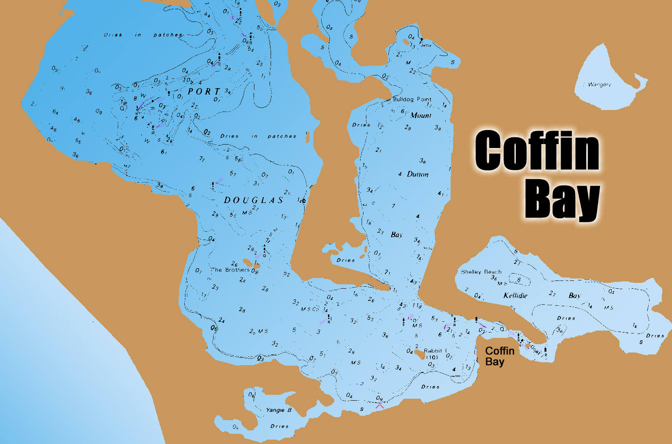
Coffin Bay is one of South Australia’s great fishing locations.

The area has sheltered tidal areas ideal for trailerboaters and yakkers, with deep offshore reefs accessible to those with bigger boats, along with several islands.

There are surf beaches and other landbased spots to the north and south.

The fishable area is huge, with good boating facilities at the township despite it being inhabited by fewer than 1000 permanent residents.

The offshore waters offer exciting fishing for tuna, samson, kingfish, snapper, morwong, nannygai and more.

Most holiday fishos target the inshore waters, with king george whiting the main species sought.

The KGs are usually found on the edges of weedbeds out of the main current of the deeper channel areas.

One of the best whiting areas is out of Farm Beach, at the Coffin Bay entrance.

To reach this area skippers can beach-launch at Farm Beach, or make a 15km run from the town ramp.

Whiting can be caught from shore at times. The boat ramp area, and the ledge opposite the township, are as good as anywhere, and the shoreline at Mt Dutton Bay.

Winter is arguably the best time for chasing whiting.

Garfish and tommy ruff respond well to berley in summer.

A highlight of the area is a spring run of big yellowtail kingfish that move into shallow Kellidie Bay.

These fish can be targeted in small boats and sight fishing is possible, one of the state’s fishing highlights.

Snapper are caught within the bay in the channel and other deeper spots, but the water is very clear and light tackle and fresh bait is a must. Fishing at night improves your chances.

The Coffin Bay peninsula is 40km in length but conventional vehicles can only go as far as Yangi Bay. From there you need 4WD and sand driving ability.

On the western side of the peninsula Gunyah and Almonta Beaches produce salmon. The sand is soft, so take a compressor and deflate your tyres. Winter fishing is best, but summer produces salmon at times.

The east side of the peninsula has small beaches and points that produce whiting, garfish, silver trevally and small salmon. Try Black Springs, Seasick Bay and Point Sir Issacs.

There are several campgrounds in the national park.

The coast between Point Sir Isaacs and Whidbey Point is not accessible by vehicle but can be reached by fit fishos on foot. The rocks produce better-than-usual fish, including whiting, sweep, nannygai, blue groper and snapper.

From February to April, tuna feed near Point Whidbey.

Outside the bay, for those with suitable boats, and a window in the weather, nannygai, morwong and snapper are caught on the deeper reefs near Sir Isaacs and north to Coles Point. Most of the reefs are to 35m depth.

Out wider, from January to April, southern bluefin tuna are caught. The schools start from around Whidbey Point, buty the best grounds are around Four Hummocks, Greenly Island and Rocky Island. Expect fish of 10kg to 20kg. .

The deep reefs around Greenly Island have kingfish and samson but rarely produce snapper. These reefs rise from 80m to about 40m.

For families, fishing the Coffin Bay shallows for silver trevally, flathead, snook, squid and flounder is fun and offers relative safety.

For those with 4WD vehicles, beach launching is possible at the southern end of Avoid Bay.

North of Coffin Bay there is rock and surf fishing at Coles Point, Greenly Beach, Convention Beach and Drummond Point.

Coffin Bay is famous for its oysters, and finding a feed of southern rock lobster is usually easy enough when the weather is suitable.

Beware breaking waves around shallow reefs when fishing outside of the sheltered waters.

A series of markers provide boaters with the best path to navigate in and out of the Coffin Bay “port”.

If there is a downside to fishing this region, it is that – if you are bait fishing – you will be pestered by endless rays and crabs.

Here is the SA seasonal fishing calendar for various fish species.

Book your fishing stay early at Booking.com

GPS marks in WGS84

Greenly Island North
34° 36.667S
134° 49.445E

Greenly Island East
34° 35.227S
134° 57.735E

Whidbey Point Wide
34° 36.341S
135° 02.897E

Perforated Island North
34° 41.660S
135° 09.729E

Perforated Island North
34° 41.029S
135° 07.365E

Sir Isaac Wide
34° 22.767S
135° 01.054E

SA fishing map
Coffin Bay tides
SA fishing regulations
SA marine parks

NOTE: Special snapper rules apply in South Australia – more info here.

Email corrections, additions, pictures or video here.

Port Phillip Bay Wrecks and Reefs

Melbourne (Williamstown) tides
Port Phillip fishing spots
Western Port fishing spots
VIC fishing regulations
VIC marine parks
Victorian stocked fishing spots

There are many locations in Port Phillip Bay that are of interest to fisherman and/or divers.

Not all wreck locations can be fished, some are historic sites and anchoring is not allowed, and some are located in shipping channels, which also means no anchoring …

1. South Channel navigation markers – these are covered in marine growth and often have nearby fish.

2. SS Wauchope wreck at approx 19.700S 144 44.680E This was a steamer 38.7m long. The ship caught fire and sank. The wreck remains are home to fish, stingrays and more. The boiler is the main feature.

3. Portsea Pier reef – this rocky reef is west of the pier and holds fish.

4. Portsea Hole, 13-28m deep at 38 18.684S 144 42.651E – an old submerged part of the Yarra River, with rock walls and ledges. Wrasse, morwong, cuttlefish, leatherjackets, boarfish, squid and flathead. A wreck exists in 25m of water on the east side of the hole on sand, located towards the pier.

5. Hurricane wreck, 12m deep at approx 38 20.455S 144 52.308E. The 1198 ton iron vessel was 70m long. In 1869 it hit Corsair Rock at the Heads and sank off Rosebud. Not much left but enough to hold fish.

6. Ranelagh Beach/Cahill’s Reef starts with shallow shoreline rocks. In the deeper water Cahill’s Reef is marked with a beacon. It holds mixed fish.

7. Carrum Artificial Reef is the first known Australian artificial reef, built in 1965. It includes the SS Uralba wreck at 18m deep at 38 04.630S 145 02.342E. The original reef of 350 concrete pipes was sunk 8km off Carrum over four hectares. The pipes sank into the silt. A concrete vessel was added in 1967 and in 1971 the 52m timber hulk of the Uralba was filled with ballast and sunk. The remnants have fish.

8. Dozens of aircraft lie in the bay, many still unfound. Those known include two Firefly WWII aircraft wrecks at 20m deep, at approx 38 06.091S 145 00.627E 38.06.004S 145 00.714E 38.05.980S 145 00.692E. They crashed during training in 1947 and lie near Carrum Artificial Reef. Divers found the wrecks in 2007 and they are now official war graves. There are two Supermarine Seafires in the bay, having been damaged and dumped overboard.

9. Mordialloc Tyre Reef, 10m deep at approx 38 03.088S 145 04.568E In 1973, three tyre reefs were installed over sand, being about 1000 tyres each, tied in bundles of eight, sunk along with rock, concrete and steel. Only the reef off Chelsea is still intact. Fish include boarfish, snapper, ling, red mullet, leatherjackets, pike,  flathead and more.

10. Sandringham Sub J-7 – this was scuttled as a breakwater and forms part of a marina. The hull shows at low tide. The rock wall also has the wreck of a 44m dredge Francis Henty. This lies near the wall’s north-west end in 4m of water.

11. The Ozone and Dominion, 3m deep at The Indented Head on Bellarine Peninsula Drive goes to a beach where the wreck of the paddle steamer Ozone can be seen at low water about 50m from shore. In 1925 it was sunk as a breakwater, now being just a debris field. Just 20m to the north is the Dominion, also sunk as a breakwater.

12. Swan Island Submarine J3, at 6m deep. This was one of six ex-RAN subs scuttled in the area. The J3 was scuttled as a breakwater in shallow water.

13. Eliza Ramsden wreck, 12-21m deep, 38 17.632S 144 40.445E. The 45m iron barque struck Corsair Rock before floating down South Channel and sinking. It was a hazard so was blasted. The bow rises within 14m of the surface over sandy and rock. There are kingfish, boarfish, cuttlefish, leatherjackets, wrasse, flathead and more.

14. Ramsden Reef, 20-30m deep. The wreck of the Eliza Ramsden is surrounded by rocky reef with leatherjackets, sweep, trumpeter, snapper, trevally and more.

15. HMAS Goorangai wreck, 16m deep, at approx 38 17.300S 144 41.130E, is a war grave. The ship sunk in a collision, with 24 sailors lost. The site lies in the South Channel on sand. The wreckage is scattered. The area has strong currents, with kingfish in the vicinity.

Port Phillip Bay Landbased Artificial Reefs

External video above is about the bay’s artificial reefs.

Three artificial reefs have been installed for Port Phillip’s landbased anglers.

They were installed in 2012 about 40m seaward of Frankston Pier, and 40m to 70m seaward of Portarlington Pier’s rock-wall section, and off the end of Altona Pier.

Each reef is 99 concrete reef balls of different sizes in three complexes of 33 reef modules each.

The reef modules are between 170kg and 340kg in weight and 50cm to 60cm in height, with openings to allow movement of currents and fish.

The modules are within casting distance of the piers.

Melbourne (Williamstown) tides
Port Phillip fishing spots
Western Port fishing spots
VIC fishing regulations
VIC marine parks
Victorian stocked fishing spots

Email corrections, additions, pictures or video here.

Book your fishing B&B early at Booking.com


Buy Redback on eBay