The coast from Warroora Station to Exmouth Peninsula, incorporating Ningaloo Reef, makes up one of Australia’s most spectacular marine habitats, and it has some of Australia’s best coastal camps.
Beach camps are run by WA parks authorities.
Most camps have easy access to beach fishing, but not all have boat launch sites.
For government camps, check the website www.parks.dpaw.wa.gov.au for the latest info to plan your trip.
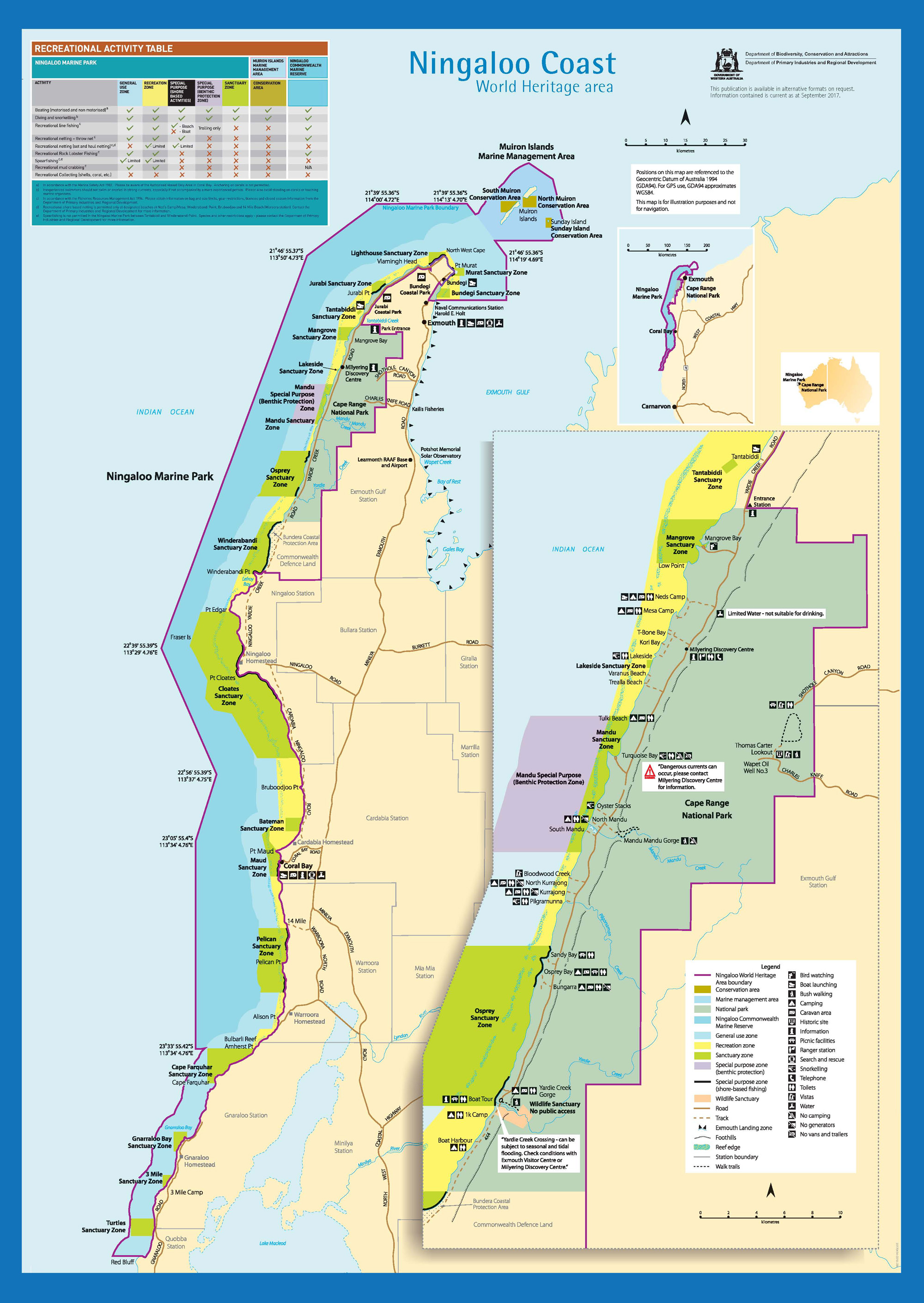
Ningaloo is Australia’s largest fringing coral reef, at 260km long. It lies just 100m offshore at its closest point, and less than 7km at its furthest.
The Continental Shelf lies just 18.5km out.
Ningaloo Marine Park was opened in 1987 and covers 4000sqkm from Amherst Point in the south to Bundegi Reef in Exmouth Gulf to the north.
The park extends about 18.5km to sea.
Coral Bay has the only proper boat ramp in the immediate area, but there are beach launching sites.
On the stations, drivers must stick to tracks to prevent dune erosion, and carry fuel, food and water.
Visitors must take rubbish home and campers in some areas must have portable toilets.
Be prepared for private bag limits. Warroora Station, for example, has a 5kg fish fillet limit.
Ningaloo waters provide flats, beach, reef and offshore game fishing opportunities.
The beaches have permit, bonefish, queenfish, golden trevally and spangled emperor in the reef lagoons. Fly fishos have fine sport.
Out wide are emperor, cod, tuskfish, coral trout, mackerel, trevally, cobia and more.
Because the Continental Shelf comes close to the mainland, trailerboaters have a rare chance to catch blue, black and striped marlin, sailfish, wahoo, dolphin fish, mackerel and even broadbill swordfish.
Ningaloo has great dive sites from Gnaraloo through to Exmouth.
Whale sharks to 12m long are sighted from March to May, as they swim near the surface.
Whales are commonly seen near shore mid-year.
Fishing charter boats work from Coral Bay and Exmouth.
Fishermen can have a fine time using a dinghy at Ningaloo during calm weather.
However, to go outside the reef requires a seaworthy boat.
Getting there
The Ningaloo region is 700km north of Perth, and 130km north of Carnarvon.
A 4WD vehicle is not needed within much of the Cape Range National Park that encompasses the Ningaloo coast, but is needed to drive beyond Yardie Creek.
The Yardie Creek crossing can be hazardous when the sand is low and there is tidal influence.
Sand driving in this area requires deflated tyres.
To reach Warroora Station, from the north take the Warroora Northern access 15km south of the Coral Bay turn-off.
Seasons
Most visitors come between April and November.
High temperatures, strong winds and cyclones discourage summer visits.
Good fishing is had all year.
Bait & Tackle
A good surf rod is a must for beach and rock fishing in this area, together with some chrome lures for distance casting.
Balloon rigs are popular for getting baits out to the fish.
Ganged hooks and pilchard baits work well on tailor, mackerel, cobia and reef fish too.
Boat fishing requires everything from handlines to trolling and spinning rods.
Pelagic fish schools are common, so a spinning rod is a must.
Rock fishing outside the confines of the reef lagoons is dangerous. Never fish the lower ledges.
Boat launching
There are sealed ramps at Bundegi (north of Exmouth), Tantabiddi Creek and near Coral Bay.
Beach launching is required in many places, and is the only way south of Yardie Creek.
The beaches are generally calm as they are inside the protective reef.

Ningaloo tides
Book Ningaloo camping
Quobba Station
Warroora Station
WA fishing regulations
Ningaloo Marine Park map
Ningaloo Marine Mark – state
Ningaloo Marine Park – federal
Return to WA Fishing Map
Email corrections, additions, pictures or video here.