Glenelg River, Victoria

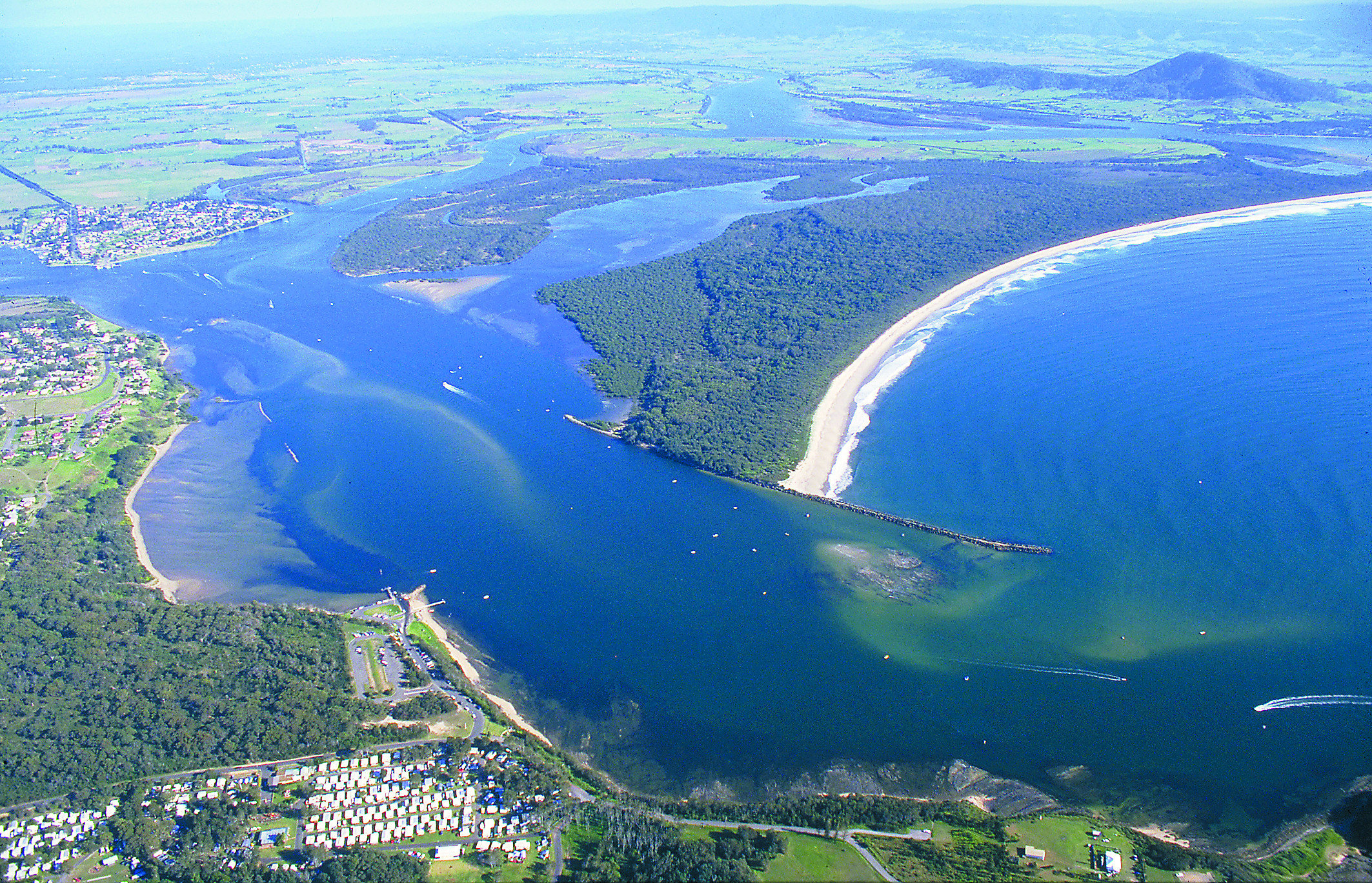
Glenelg River is a hugely popular fishing destination that flows to sea near Nelson, meandering through both South Australia and Victoria.

The estuary extends about 60km upstream, with most of it located inside the Lower Glenelg National Park.

The Glenelg is Victoria’s third longest waterway at 350km, yet the sea entrance occasionally closes over at the mouth, which causes the river level to rise.

This relatively deep river is about 50m or so wide in the lower section, with scenic cliffs and forest along the lower reaches.

The south-west walking track follows 40km of river.

There are 29 launch sites along the river for small vessels, along with formed boat ramps for trailerboats, and many sites have picnic facilities.

Some of the more popular launch sites are Nelson, Isle of Bags, Simsons Landing, Donovans Landing, Sandy Waterholes, Sapling Creek, Wilson Hall, Pritchards and Saunders.

Boats can be hired at Nelson.

Tidal influence reaches to above Saunders, when the waterway becomes more difficult to navigate, becoming narrower, with plenty of submerged timber.

South Australian boating regulations apply in the SA section.

Twenty five fish species have been recorded in the estuary, with black bream, yellow-eye mullet, salmon, estuary perch, mulloway, luderick, flathead and flounder the most common.

Baits recommended are sandworms, peeled prawn, whitebait, crabs and clickers.

Big bream and school mulloway are the main interest to fishermen, but there are a great many small picker bream to get through.

Mulloway are best from September to December, but can be caught from November to May, with a few stragglers caught outside these times.

The river’s mulloway tend to be on or off, possibly with the presence of a school(s) determining whether there is much action or not.

Heavy rain will flush small fish down the river and mulloway will usually be waiting in the lower section.

Glenelg mulloway are smallish fish, with the occasional specimen cracking 10kg. Livebait works best on them.

The beach at the river mouth looks shallow but can be a mulloway hotspot at times.

Mulloway are most often caught in the estuary up to around the highway bridge.

For mulloway, also try the caves region. Use pilchard, fresh squid or live mullet baits at night.

Major bream competitions are held on the Glenelg River.

Typically, bream fishos cast small lures to bankside and other structure.

In winter the bream school in deeper areas, while in summer they move upstream.

The best area for bream is from the river mouth upstream to Pritchards, with the better fish often caught in the Sapling Creek region.

During holidays there is a lot of boat traffic and better bream fishing is usually had in the early morning, late evening and night, or by travelling far upriver.

There are landbased fishing opportunities along the river around Nelson but a boat or yak is needed to fish the best spots in the river.

Surf beaches at nearby Nobles Rocks and Swan Lake near Nelson produce salmon, school mulloway and gummy sharks after dark, with occasional school sharks.

Browns and Piccaninie Beaches also produce gummy sharks and mulloway after dark. Fish a big high tide at night in summer for the best chance of success.

Book your fishing stay early at Booking.com


fish finder book

Glenelg River entrance tides
Glenelg River region beaches
VIC fishing regulations
VIC marine parks
Return to the VIC fishing map

Email corrections, additions, pictures or video here.

Danjera Dam, New South Wales

Danjera Dam is 20km west of New South Wales’ Nowra.

The dam was built in 1971 on Danjera Creek, a tributary of the Shoalhaven River.

Though only a relatively small dam at 90ha in area, it is a scenic spot and can fish well, making it popular.

The dam contains stocked bass and rainbow trout, and a natural stock of eels.

Most fishos target the bass, which often respond well to lures, especially in warm weather.

The rainbow trout take up the slack in cooler weather.

There are camping areas, toilets, barbecues, firewood, water and bins.

The dam is up to 30m deep, with an average depth of around 15m.

Only electric motors, sail or oar powered vessels are permitted, so it is a peaceful place to fish.

NSW dam levels
NSW stocked waters
NSW fishing regulations
NSW marine parks

Email corrections, additions, pictures or video here.

Nowra, New South Wales

The Crookhaven River entrance. Picture: John Lugg, NSW Government.
Nowra boating map
Part of a Nowra boating map by the NSW Government. Click here to download the full PDF.

Nowra has great fishing on the Shoalhaven River.

The river has 50km of tidal water, much of it shallow.

Nowra township is 18km upstream from the entrance.

The river has two sea entrances, one permanently open to the south at Crookhaven Heads, a joint mouth of the Crookhaven and Shoalhaven Rivers, and the other intermittently open 5km to the north at Shoalhaven Heads.

The Shoalhaven River has most typical NSW estuary species, with bream, flathead and whiting the main catch, but also with luderick, mulloway, estuary perch and bass.

The river is shallow and usually clear and for this reason can be a challenging fishing location.

Winter sees a good run of luderick, with big flathead in summer.

Perch are often found near the deeper rock walls.

The Crookhaven mouth’s north shore bordering Comerong Island has good flats and weedbeds, with a rock wall that has landbased fishing, accessible via a ferry.

The inner wall has mainly luderick, while the outer wall has tailor, bream, flathead and mulloway.

The lower Crookhaven has dense mangrove areas bordering extensive flats which fish well for whiting, bream and flathead.

‘The Canal’ runs between Comerong Island and the southern mainland and is lined with rock walls.

The walls on the south bank have bream and luderick.

Local oyster racks produce good fish.

The rock walls at Greenwell Point, the wharves at Orient Point and the breakwall on Comerong Island are all good places for large bream, flathead and winter luderick.

At Nowra, the flats at the end of Pig Island have flathead, whiting and bream.

There is rocky reef between the island and the bridge, and navigating the north shore requires care, but the deep water next to it holds bream, luderick and mulloway.

The bridge pylons hold fish. Upstream of the bridge are rock walls with bream, flathead, whiting, mulloway and estuary perch.

The NSW Government installed an artificial reef 4.3km north-east of the Shoalhaven River entrance in 33m of water in January 2015, at 34 50.955S 150 47.731E (WGS84 datum).

There are 20 concrete modules in five clusters, five modules per cluster.

Kingfish, trevally, snapper, morwong, tailor, salmon and mulloway are the main catch, as well as baitfish.

To the north of Nowra the Gerringong area has good inshore boat fishing, with Werri Drift a proven flathead ground along Werri Beach, about 750m offshore.

Gravel Patch is 2.5km off the northern point of Werri Beach and has morwong and flathead.

The Crack in the Wall is almost 2km directly off Walkers Beach, with morwong and flathead.

There is broken reef between Black Head and Werri Point. The regions bass dams are Tallowa, Danjera and Flat Rock.

Stocked waters near Nowra include Danjera Dam, Flat Rock Dam and Tallowa Dam.

Great fishing can be had south of Nowra at the outstanding fishing location of Jervis Bay.

Book your fishing stay early at Booking.com


fish finder book

Nowra tides
Nowra region coastline
Shoalhaven artificial reef
NSW Govt Nowra fishing guide PDF
NSW Govt boating map PDF
Shoalhaven surf report with cam
NSW fishing regulations
NSW marine parks

Email corrections, additions, pictures or video here.

Book your fishing B&B early at Booking.com


Buy Redback on eBay