Moruya River, New South Wales

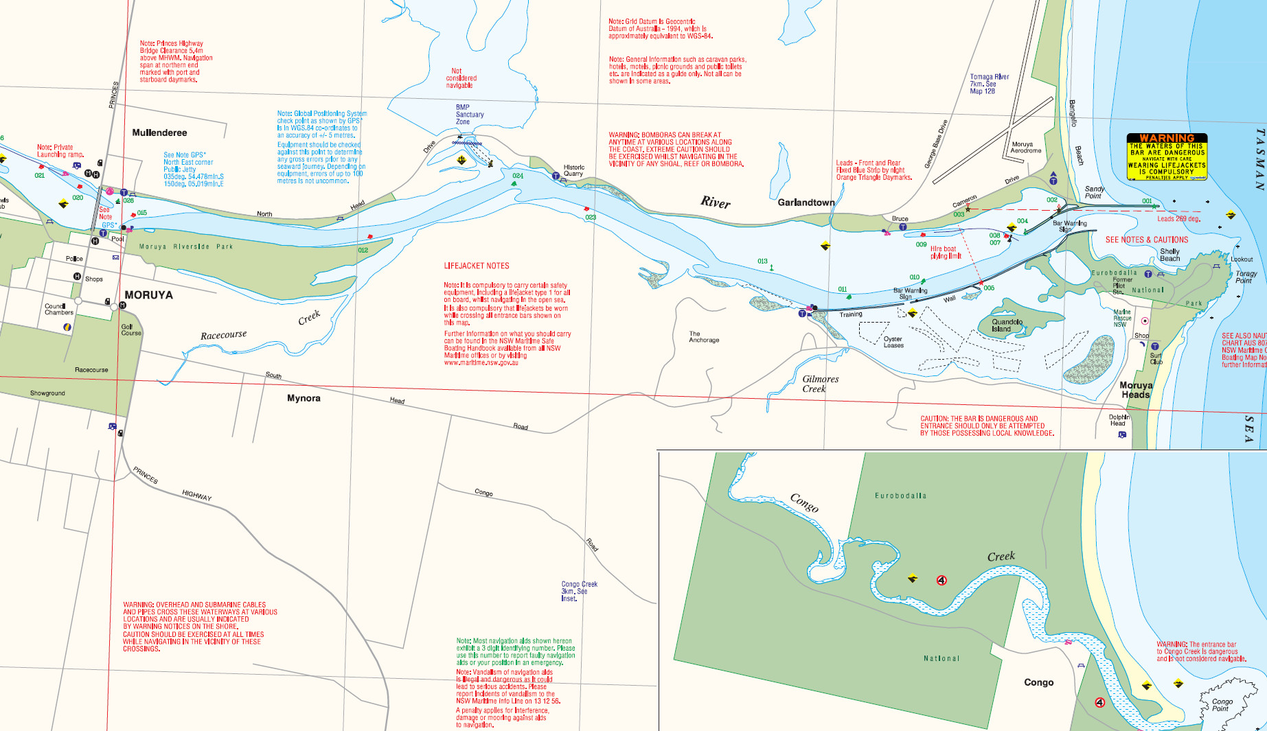
A NSW Government Moruya River boating map
A NSW Government Moruya River boating map. Click here to download the full PDF
Moruya River mouth ... the rock walls produce big fish. Picture John Lugg, NSW Govt
Moruya River mouth … the rock walls produce big fish. Picture John Lugg, NSW Govt

The Moruya River has 20km of tidal water, becoming Deua River and Burra Creek in the upper reaches.

The river is shallow, running mostly 2m to 3m deep, with many sandbanks and rocks upstream of the highway bridge.

Small-boat access is generally good except for 1km of river adjacent to the highway bridge.

Most fishing is done between the Moruya bridge and the sea entrance, an area that has fishable rock walls, weedbeds, flats and side creeks.

flathead and whiting are the drawcard on the Moruya and can be caught on lures or bait by drifting or casting.

Bream are also usually about, and the river has estuary perch and bass.

The Moruya River has good landbased access, with fishable rock walls on the northern and southern sides.

Bream, tailor, salmon, luderick and flathead are the main catch from the walls, with a chance of mulloway.

For boaters, the rock walls in the lower river are also the best place to fish for bream, tailor, trevally, mulloway, luderick, salmon, kingfish and flathead.

The lower river flats on the north side are the place for whiting and flathead. Try casting to the edges of weedbeds.

Quarry Wharf has mainly bream, flathead and tailor, while Preddys Wharf near Moruya Heads has bream, whiting, flathead, mullet, garfish, trevally and luderick.

Dolphin Beach and Pedro Point nearby have good beach fishing, with mainly flathead, bream and whiting. Beach worms are the best bait, but squid or prawns also work.

Shellys Beach is another good spot.

Moruya bridge pylons usually hold flathead, bream and luderick, with a chance of estuary perch.

The upper Moruya has bream and bass in winter.

As with all NSW rivers, heavy rain tends to push marine fish down the river, and mulloway may be feeding on flushed bait at the sea entrance after flooding.

Good boat fishing can be had in 50m-60m of water off Pedro Point and Congo. flathead, snapper, mulloway, kingfish, leatherjackets, tailor and salmon are caught.

Given a choice, most river fishos prefer to fish the nearby Tuross system, which is larger and hence has more fishing options, but nonetheless the Moruya is a great place to fish.

Book your fishing stay early at Booking.com


fish finder book

Moruya Heads tides
Moruya coastline
Moruya bar webcam
NSW fishing regulations
NSW marine parks

Email corrections, additions, pictures or video here.

Tuross, New South Wales

Tuross Lake ... a South Coast estuary fishing mecca. Picture John Lugg, NSW Govt
Tuross Lake … a South Coast estuary fishing mecca. Picture John Lugg, NSW Government
A NSW Government Tuross Lake boating map
Part of a NSW Government Tuross Lake boating map. Click here to download the full PDF

A vast expanse of shallow fishable estuaries surrounds Tuross.

These are Tuross Lake and Tuross Broadwater, with Coila Lake immediately to the north.

The vast estuary system forms the downstream section of Tuross River.

This area has been described as the gem of NSW’s South Coast.

Commercial fishing was banned locally in the 1980s.

The system is now productive for bream, tailor, salmon, luderick, flathead and whiting, as well as prawns.

The system of flats and channels runs to about 4m deep, with Tuross Head located north of the permanently open sea entrance.

The tidal limit in the Tuross River is at Comerang, 19km from the entrance, 9km upstream from the highway bridge, north of Bodalla.

Coila Lake, immediately north of Tuross, reaches 3m depth and usually has a closed entrance, but prawns and fish thrive.

The Tuross estuary is known for its trophy flathead, usually caught in spring, with fish 90cm and bigger taken. Special rules apply to these big fish.

The bigger sand whiting are usually caught near the river mouth.

The oyster racks are the best place to chase bream.

Upstream around Tuross Bridge and Snake Flat off Bumbo Road bass are caught. but these shallow waters are only suitable for cartopper or yak.

Coila Lake is famous for prawns, but it also has good bream.

The main boat ramp for the Tuross system is at Lavender Bay near the river mouth, with a second at the Tuross Bridge on the Princes Highway, 6km south of the
Tuross Head turnoff.

This second boat ramp is used to access the estuaries to the west of Tuross Bridge.

Coila Lake has two boat ramps, the first at Kyla Sporting Complex and the second at the end of Foam Street.

Book your fishing stay early at Booking.com


fish finder book

Tuross tides
Tuross coastline
NSW fishing regulations
NSW marine parks

Email corrections, additions, pictures or video here.

Jervis Bay, New South Wales

Jervis Bay is a hugely popular fishing destination with a combination of estuary, rock, surf and game fishing.

The bay is about three times the size of Sydney Harbour, with plenty of space for boating during holiday periods.

It is less than a three-hour drive south of Sydney,

Jervis Bay has some of Australia’s best game fishing rock platforms, being one of the few Aussie landbased locations where yellowfin tuna and marlin are reliably caught.

There are usually ample squid and bread and butter species in the bay and for this reason, along with the great surroundings, holiday periods can be busy.

Offshore there are canyons along the Continental Shelf that produce blue, striped and black marlin, and mako sharks.

Yellowfin, bonito and albacore are the main tuna species.

Gamefish are taken mainly in the warmer months.

Yellowtail kingfish and tailor numbers vary from year to year, while drummer and bream are almost always present off the rocks.

Jervis Bay Marine Park covers about 100km of coastline from Kinghorn Point south to Bherwerre Beach.

About 80 per cent of the park is zoned “habitat protection” and “general purpose” which both allow recreational fishing, but there are several sanctuary zones.

The small towns around the bay are Callala Bay, Callala Beach, Myola, Woollamia, Huskisson, Vincentia and Hyams Beach, with accommodation, van parks and camping grounds.

The southern bay is Commonwealth territory with naval training facility HMAS Creswell.

This area forms the Booderee National Park.

Jervis Bay has protected low-energy beaches, and clear waters over fertile seagrass beds, making for great squidding and enjoyable boating.

Big flathead can be caught from most beaches.

Reefs extend north and south of the bay entrance, with good fishing, but many boaters go wider.

Offshore game grounds accessible from the bay include The Sir John Young Banks, JB Canyons and Drum Canyons.

The main inflowing waterway is Currumbene Creek, at Huskisson, with several smaller creeks also flowing into the bay.

The water in the bay tends to be very clear, so coastal fishing is more successful using light gear and at dusk, dawn and at night.

If you plan to chase gamefish from the rocks you will need specialist gear. The best platforms are somewhat famous and the local tackle shops will point you in the right direction.

Keep in mind that rock fishing is hazardous, and unfortunately there is some reluctance to wear life preservers among Aussie fishos.

Jervis Bay fishing spots

Murrays Beach boat ramp and rock wall – the beach is within Booderee National Park. Very clear water, best fishing as at dawn and dusk. at dusk. Great spot for squid because of the weedbeds.

Plantation Point – bream, flathead, flounder, whiting, squid and snapper.

Currarong – there is rock, beach and good boat fishing here. Beach fishing at Warrain and Abraham’s Bosom Beach, with otherr beaches a short drive away. Salmon in winter, tailor, flathead, whiting and bream off the beaches, with a chance of mulloway at night. Landbased game fishing off Point Perpendicular.

Hyams Beachbream, whiting, flathead and salmon.

Huskisson Wharf – easy family fishing but a lot of bait pickers here..

Currumbene Creek – there are several good landbased spots in this creek, expect bream, whiting, flathead, luderick and flounder.

Moona Moona Creek – try the hole under the bridge for bream, whiting, flathead and luderick.

Callala Baywhiting, bream and flathead from the beach, with squid, flathead, salmon and tailor off Callala Point rocks. The jetty next to Callala Bay boat ramp produces few fish.

In this general region, St George’s Basin Recreational Fishing Haven is another great fishing spot, with artificial reefs installed at a depth of 6.5m.

Also in this region, Lake Conjola has a similar reef.

More great fishing can be had to the north of Jervis Bay around the fishing holiday township of Nowra.

Jervis Bay fishing GPS marks

The Banks West gamefish, snapper 34 58.100S 150 52.650E
Shark Reef East 34 57.120S 150 56.460E
SHark Reef North 34 56.640S 150 56.410E
Shorna wreck 34 58.383S 150 48.627E
Morwong ground 34 58.421S 150 58.722E
Snapper reef 34 58.442S 150 59.158E
Drop-off 34 58.958S 150 55.187E
Currarong bommie 34 59.517S 150 50.089E
Currarong bommie 34 59.18S5 150 50.110E
The Banks 34.59.300S 150.51.760E
East Reef 34.59.560S 150.50.050E
The Banks 35 00.900S 151 03.710E
Huskisson patch 35.02.214S 150.40.404E
Snapper ground 35 02.320S 151 04.461E
Flat Rock snapper 35.03.924S 150.50.459E
Middle ground 35.06.090S 150.46.193E
Jervis Bay Canyon 35.08.150S 151.02.250E
Middle ground in Sussex Inlet 35.13.39S 150.36.26E

Book your fishing stay early at Booking.com


fish finder book

Jervis Bay tides
Jervis Bay coastline
Boodaree National Park
Jervis Bay Zoning Map
Jervis Bay Marine Park User Guide
NSW FADs
NSW stocked waters
NSW dam levels
NSW fishing regulations
NSW marine parks

Email corrections, additions, pictures or video here.
Book your fishing B&B early at Booking.com


Buy Redback on eBay