NT rainfall trend looks good

WFS Admin

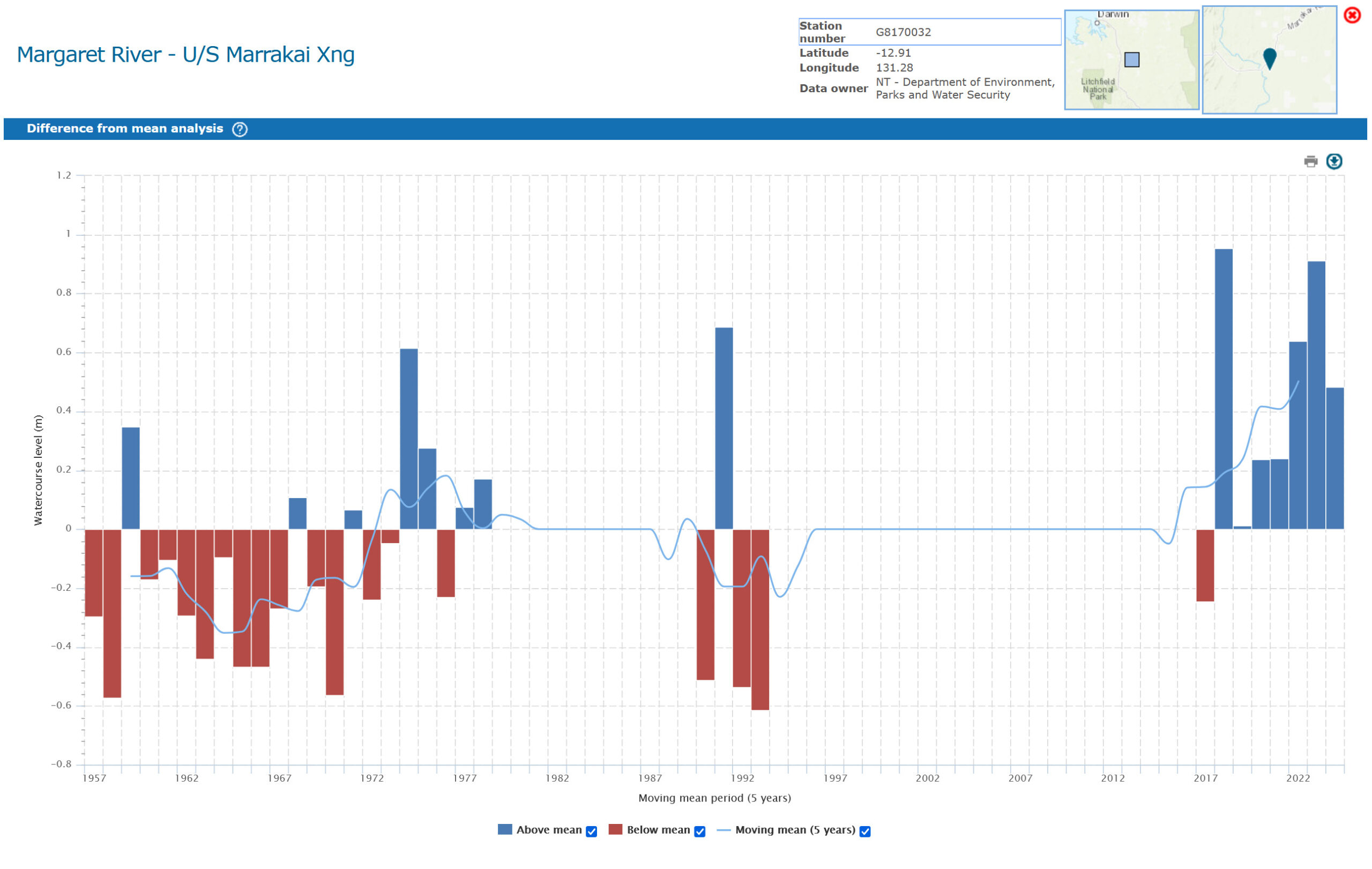
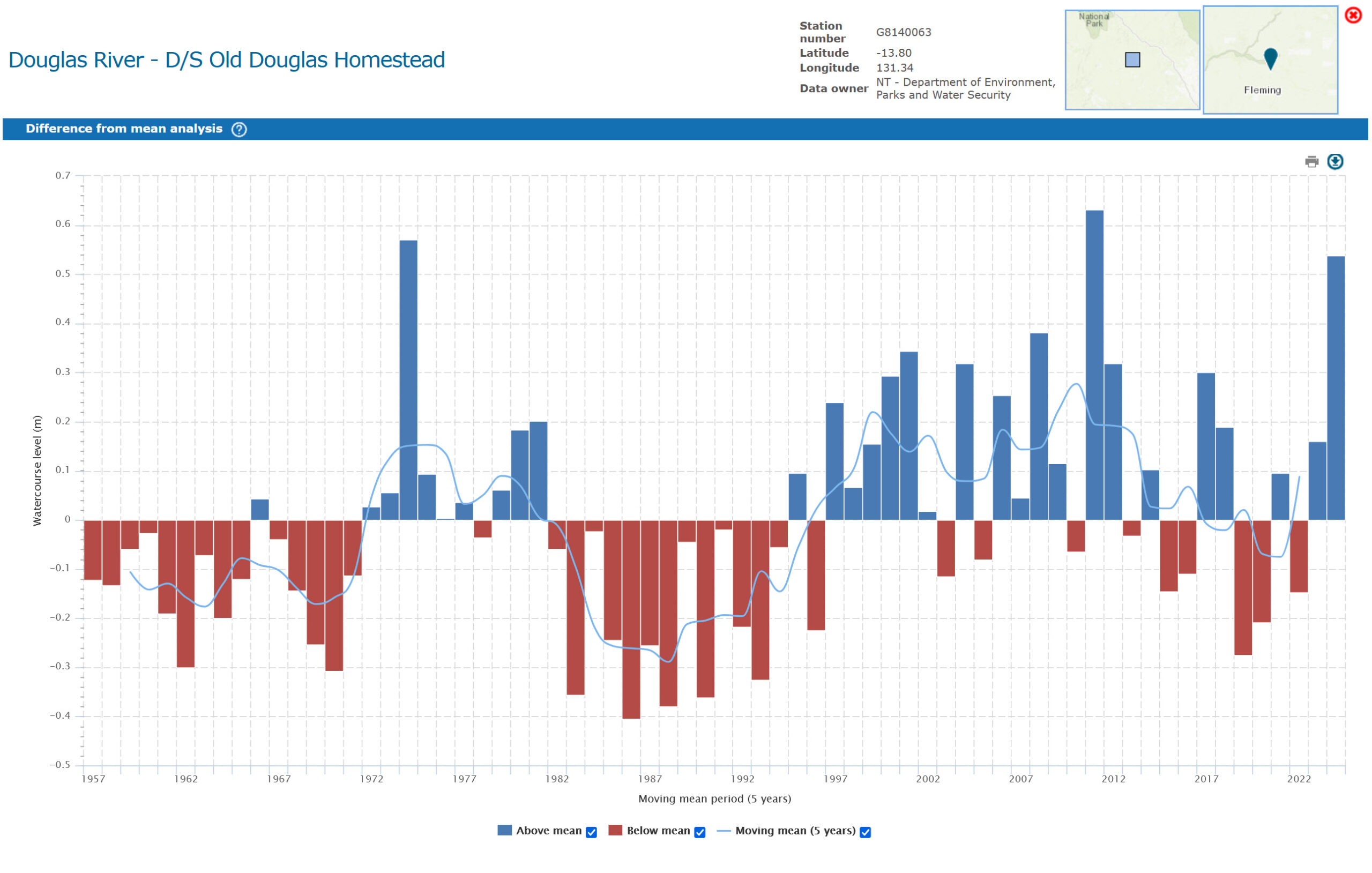
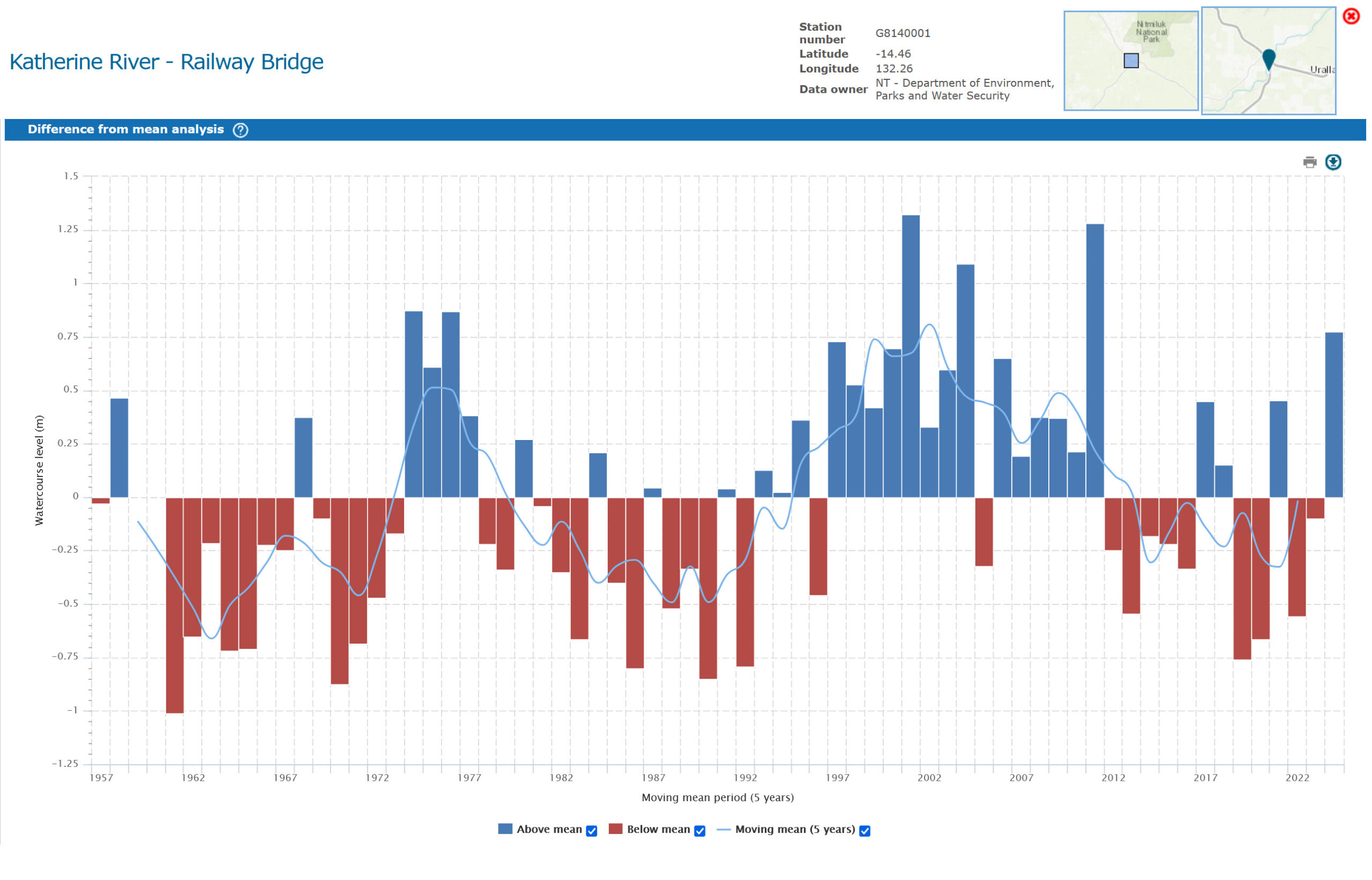
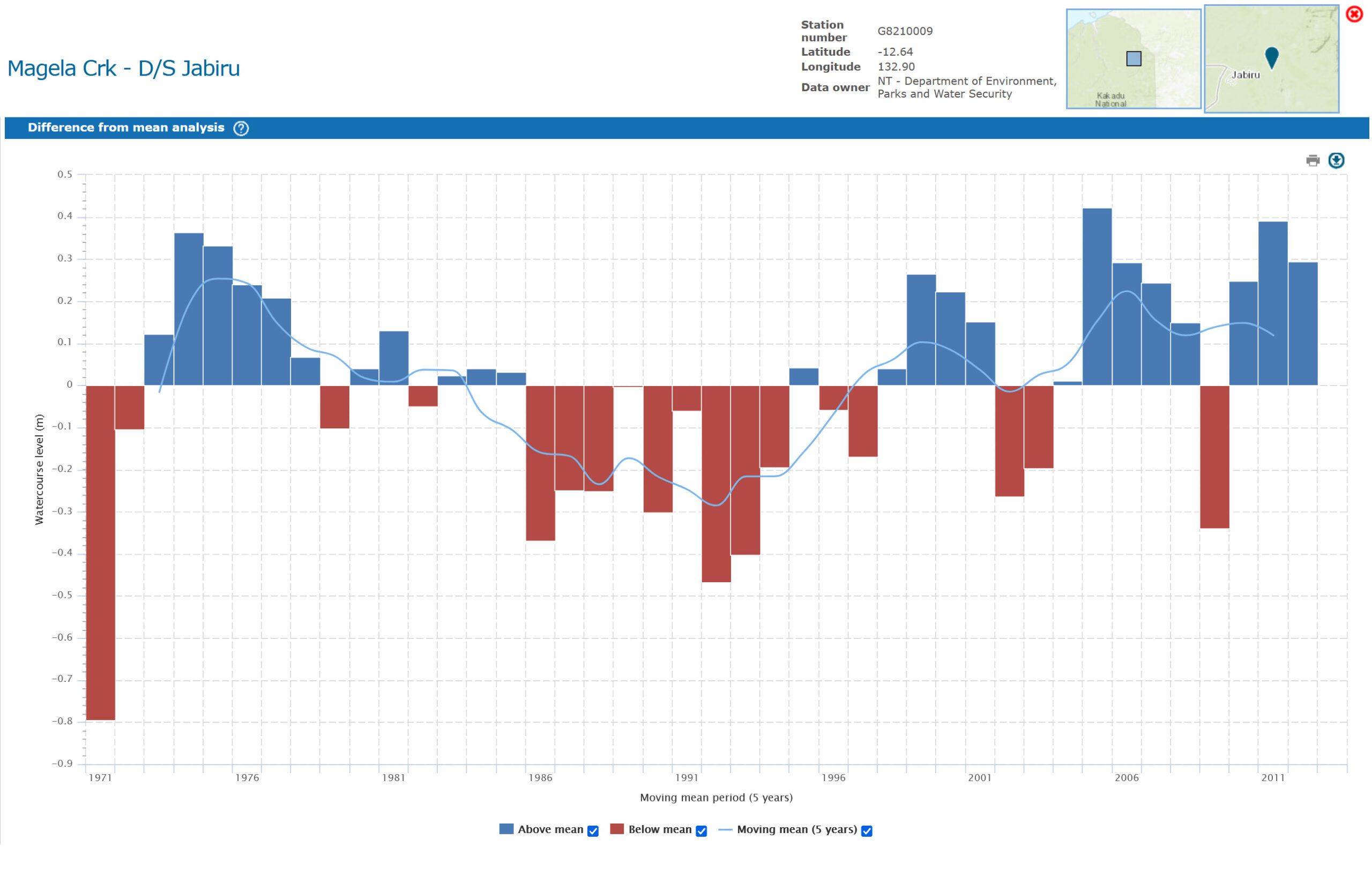
The images above show rainfall at some relevant Top End water gauges.

While the SA suffers a mass fish die-off from likely climate change-related events, the Top End is going from strength to strength thanks to increasing wet season rainfall.

Increase in annual rainfall over past decades
The Top End has had a statistically measurable increase in annual rainfall. For example, a climate-guide report from the Northern Territory Bureau indicates that from a comparison of two 30-year periods (1959-1988 vs 1989-2018), annual rainfall increased by about 110 mm (11%), from around 940mm to 1050mm.

Bureau of Meteorology – wet season / monsoonal rainfall increase
The wet season (monsoon period) rainfall has also increased in some key stations. For instance, Darwin’s wet season rainfall between Nov-Apr increased by 146mm compared to the earlier 30-year period. Daly Waters increased by 81mm.
Bureau of Meteorology

Seasonal shifts and variability
Rainfall in the build-up (the period leading into the wet season, often Oct-Dec) appears less reliable in parts of the Top End, especially the eastern part. That is, large inter-year variability and “false starts” of monsoon rains have been more common. There is also evidence that the earlier and later parts of the wet season (and perhaps associated with the monsoon onset) have become more variable. Some studies note a decrease in rainfall in the early and late wet season in certain parts.

Recent years
In 2024, for example, the Northern Territory as a whole saw rainfall totals well above average, and in some parts of the Top End or NW NT, the highest on record.

What is not fully settled
How much of the observed increase is due to long-term climate change vs natural decadal variability (e.g. ENSO, the Indian Ocean Dipole, Pacific Decadal Oscillation) is still being explored. The timing of the monsoon (onset, duration, breaks) is variable and some trends (later onset in some years) might be emerging, but the confidence is lower. The spatial differences are strong: some parts of the Top End (east vs west) show different trends. Some subregions have more reliable increases, others are more variable.

Overall conclusion
Yes, the rainfall over the Top End has been trending upwards, particularly in the wet season / monsoonal rainfall period and in aggregate annual totals, over the past several decades. But the increases come with more variability—some years of low rainfall, shifts in when rain falls, and differences in how reliable parts of the region are.

Heat is of course the wildcard, the heat trend is upward and may lead to increased billabong mortality and marine heatwaves etc.


Glory days for SA mulloway

WFS Admin

Here’s how good the Murray River mouth mulloway fishery was before the barrages were built.

The following letter appeared in the “Fisheries Newsletter” of February 1946. The author is only shown as “Mulloway”, perhaps a former commercial fisho.

Sir, before the construction, in 1939, of the barrages to prevent the escapement of fresh water, the Coorong was perhaps one of the best fishing grounds in the Commonwealth.

Huge quantities of butterfish (mulloway) and mullet were shipped annually from Milang to the Adelaide market.

Butterfish alone was worth £10,000 a year to Milang. But since the barrages were erected, commercial fishing has suffered a severe decline in these waters.

The following figures of butterfish handlings at the Adelaide markets (about seven-eighths of Adelaide receivals are shipped from the Murray mouth) vividly tell a part of the story.

During the seasons 1936-41 a total of 3,738,300lb of butterfish passed through the Adelaide market.

From 1941 until 1945 a total of 806,197lb has been handled.

Corresponding figures relating to mullet supplies are not available to me, but that fishery has fallen off practically to nil compared to results before 1940.

In January, 1940, the lakes were closed by the barrages, and from that year onwards the decline in these important fisheries has hit local fishermen very hard.

Freshwater fish have begun to show up behind the barrages, but there is little hope that catches of freshwater species will ever approximate the amounts of butterfish and mullet taken before the river was closed by the barrages.

There is no expectation on the part of fishermen that the barrages will ever be open sufficiently to enable sea water to come into the lakes like it used to, but there is a channel still open to the Coorong which, during high tides, enables fish to enter the lakes.

General opinion is that if this channel was dredged, fish could enter at any stage of the tide, and thus contribute to the rehabilitation of the fishery.

But fishermen in this district would be pleased if the Council for Scientific and Industrial Research would undertake an investigation in connection with the re-establishment of the fishery. Yours, Mulloway.

****

So, to sum up, the barrages damaged an incredible mulloway fishery, along with most of the mullet, and probably a good many black bream, flounder and flathead too.

Today, the lower lakes are full of carp. They were full of murray cod before 1912.

Before the barrages were installed, local commercial fishermen warned that the barrages would kill the mulloway fishery, which operated between December and April in the lower lakes.

Fishermen had warned that the lower lakes lost the prolific murray cod because poor quality water was being being brought downstream from upstream activities.

More recently, the barrages, located between Goolwa and Pelican Point, were opened in October 2002 because the Murray mouth was in danger of closing from low river flows.

By the early 2000s, inflows from the Murray–Darling Basin were well below average, and by late 2002 the mouth was silting up.

In October 2002, SA Water and the Murray–Darling Basin Commission opened the barrages to flush sediments. Dredging began soon afterwards.

The opening was expected to maintain estuarine health, prevent ecological collapse and keep the mouth connected to the sea.

The most significant Murray flood event in recent memory was the 2022–2023 South-Eastern Australian floods, which sent record-high flows through South Australia.

The floodwaters peaked around late December 2022, with the flow at Renmark estimated at 185 to 190 gigalitres a day, making it the highest flow since the landmark 1956 flood.

It is believed nutrients from the flood, along with a marine heatwave and other factors, contributed to the SA’s unprecedented coastal algal bloom of 2025.

Meanwhile, see a great Facebook thread about SA mulloway here.

What are South Australia’s butterfish?

WFS Admin

I was surprised to see South Australia’s dusky morwong, or strongfish, being called butterfish on social media.

As a former Adelaide fisho, whose father also grew up and fished Adelaide waters, butterfish to us was always the South Australian name for mulloway, not morwong.

Nonetheless, the name has been used for both mulloway and dusky morwong over the years, and a variety of other fish.

Strongfish, or “strongies”, are the ever-present staple of spearfishermen in Adelaide’s seagrass beds.

They taste “strong” as they apparently eat a lot of weed, however people do eat them. How you cook them and how hungry you are will likely determine your opinion of them as a table fish.

Some fishos will tell you they are called strongfish because they are powerful, but they are rarely taken on a line. They are a solid fish and they grow large.

In South Australia, especially in Adelaide and around the Coorong and lower Murray, mulloway were called butterfish because of their rich, smooth flesh – described by some as buttery.

Perhaps the strongie was called butterfish for the opposite reason – you need butter to make them taste good.

Elsewhere in the world this family fish are called butterfish … https://en.wikipedia.org/wiki/Stromateidae

A friend told me years ago that the humble pomfret was a great table fish that flew under the radar, yet another species called butterfish, as are the ever-present (in retail outlets at least) hake.

Australian fishing spots

Wiki Fishing Spots