Category Archives: Fishing Spots

Moreton Bay Artificial Reefs – North Moreton Reef

North Moreton Artificial Reef

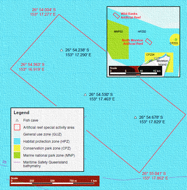
North Moreton Artificial Reef is a shallow site located north of Moreton Island.

The reef was designed mainly to attract pelagic fish for spearfishing, but fishing is also allowed.

The site consists of 25 large square concrete modules called fish boxes installed in three clusters of six boxes, covering an area of 200ha.

The average depth is 14m.

North Moreton Artificial Reef Fish Species

Trevally, mackerel, kingfish and cobia are the main catch, but other species show up as the modules attract bait schools.

Snapper, cod and flathead are also caught around the structures, but most boaters chase bottom fish on the deeper natural reefs in the region.

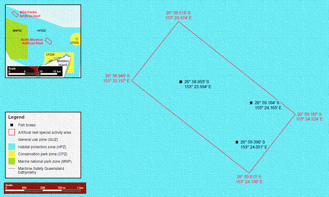
North Moreton Artificial Reef GPS Marks

Fish box clusters

26 58.953S 153 23.594E
26 59.104S 153 24.165E
26 59.390S 153 24.051E

Back to the NSW/ACT Fishing Map
Back to the NT Fishing Map
Back to the Queensland Fishing Map
Back to the SA Fishing Map
Back to the Tasmanian Fishing Map
Back to the Victorian Fishing Map
Back to the WA Fishing Map

Email corrections, additions, pictures or video here.

Moreton Bay Artificial Reefs – Wild Banks Reef

Wild Banks Artificial Reef

Wild Banks Artificial Reef consists of steel towers installed in 35m of water, east of Moreton Bay’s Wild Banks.

The towers are dubbed “fish caves”.

Each tower is an 11m-high structure of steel, 11m wide and weighing 14 tonnes each.

The total reef area covers 175ha.

The tower design attracts pelagic fish, but bottom fish are also caught, however anchoring is not allowed on these structures.

Because anchoring is not permitted, skippers use an electric motor spot-lock to fish, or just drift past the reefs while dropping baits or jigs.

The turn of the tide can bring on the best fishing.

Wild Banks Artificial Reef Fish Species

Fishermen catch mostly trevally, mackerel, cobia and kingfish on these reefs, with dolphin fish and wahoo also showing up.

Bottom fish caught include pink snapper, slatey bream, cod and tricky snapper (grassies).

The towers attract bait schools, and marlin and sailfish have been caught in the vicinity of the reefs.

Wild Banks Artificial Reef GPS Marks

Fish caves

26 54.238S 153 17.290E
26 54.530S 153 17.463E
26 54.678S 153 17.829E

Back to the NSW/ACT Fishing Map
Back to the NT Fishing Map
Back to the Queensland Fishing Map
Back to the SA Fishing Map
Back to the Tasmanian Fishing Map
Back to the Victorian Fishing Map
Back to the WA Fishing Map

Email corrections, additions, pictures or video here.

Moreton Bay Artificial Reefs – East Coochie Reef

East Coochie Artificial Reef

This reef covers a 15ha area on the east side of Coochiemudlo Island.

It is made of 174 concrete reef balls installed in 13 clusters of 11 to 16 balls.

Each cluster has balls of varying sizes rising to almost a metre off the seabed.

The balls within each cluster are a few metres apart and each cluster is 80m to 100m apart.

East Coochie Artificial Reef Fish Species

The reef produces a lot of small fish, and a few bigger ones.

The main catch is pink snapper, bream, tricky snapper (“grassies), tuskfish and flathead.

Passing school mackerel are caught.

Fish the turn of the tide, be sure to move if you don’t get bites, and try to fish mid-week and at night when boating traffic is lower.

East Coochie Artificial Reef GPS Marks

Reef Ball Clusters

27 34.106S 153 21.094E
27 34.143S 153 21.040E
27 34.159S 153 21.117E
27 34.208S 153 21.072E
27 34.222S 153 21.005E
27 34.273S 153 20.961E
27 34.283S 153 21.036E

Back to the NSW/ACT Fishing Map
Back to the NT Fishing Map
Back to the Queensland Fishing Map
Back to the SA Fishing Map
Back to the Tasmanian Fishing Map
Back to the Victorian Fishing Map
Back to the WA Fishing Map

Email corrections, additions, pictures or video here.