Category Archives: Fishing Spots

Nowra, New South Wales

The Crookhaven River entrance. Picture: John Lugg, NSW Government.
Nowra boating map
Part of a Nowra boating map by the NSW Government. Click here to download the full PDF.

Nowra has great fishing on the Shoalhaven River.

The river has 50km of tidal water, much of it shallow.

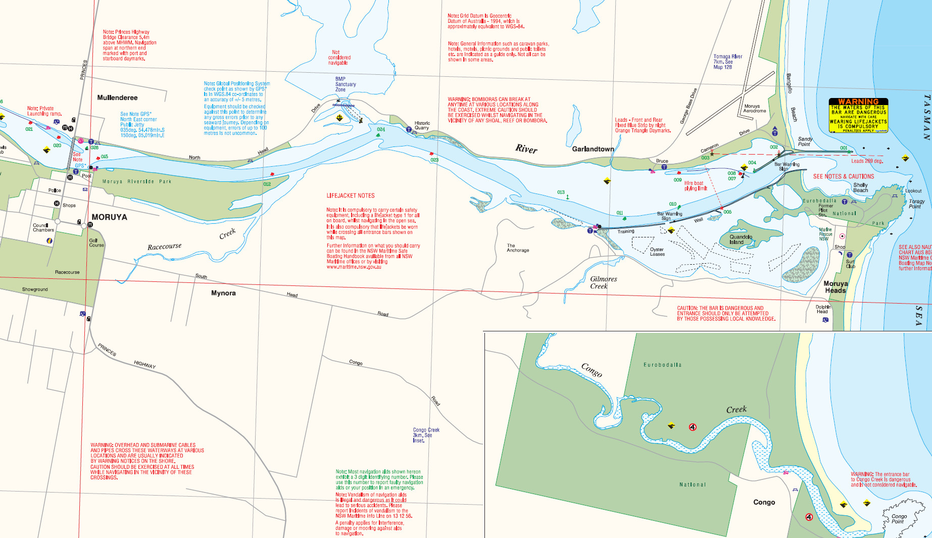
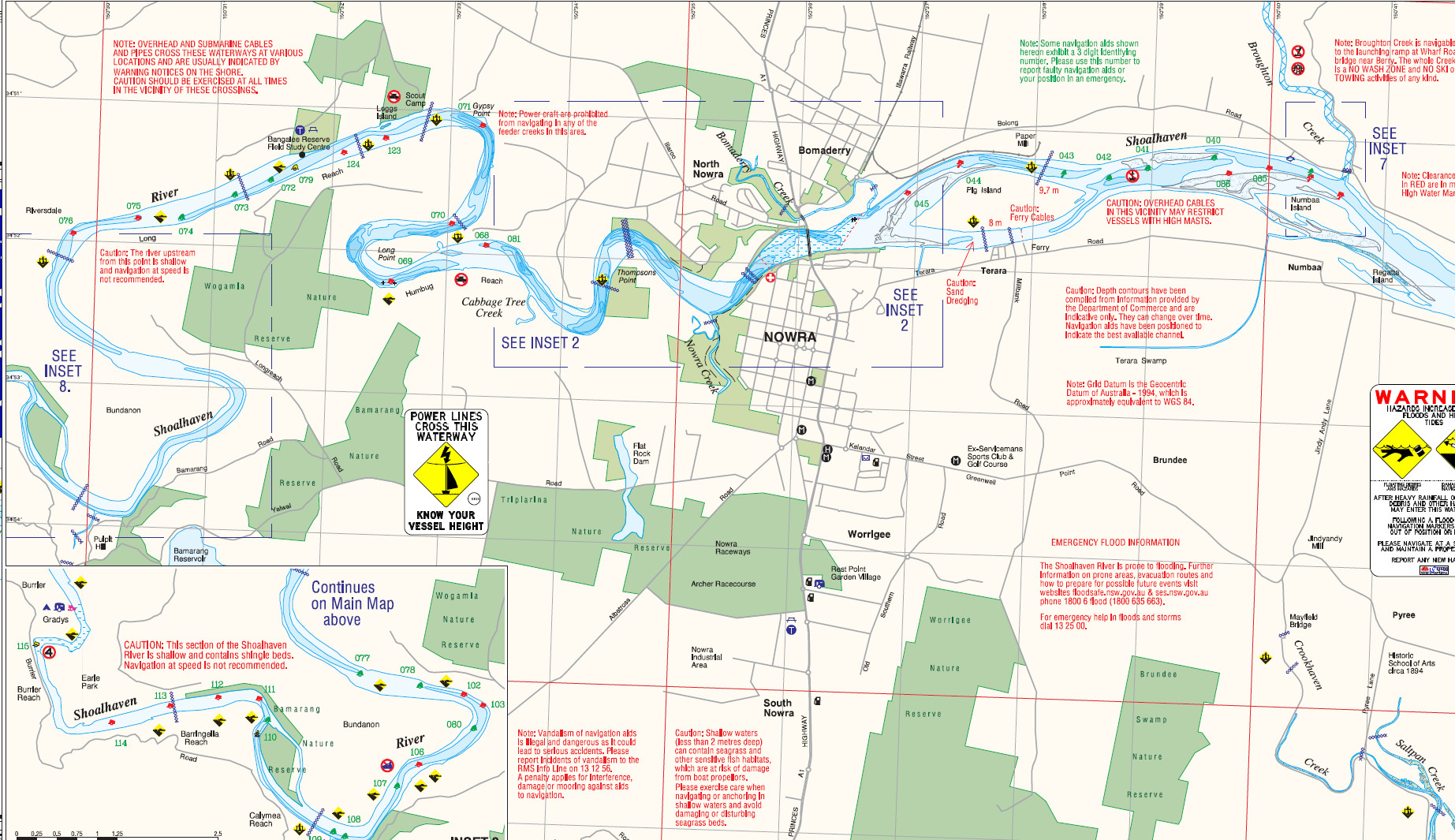
Nowra township is 18km upstream from the entrance.

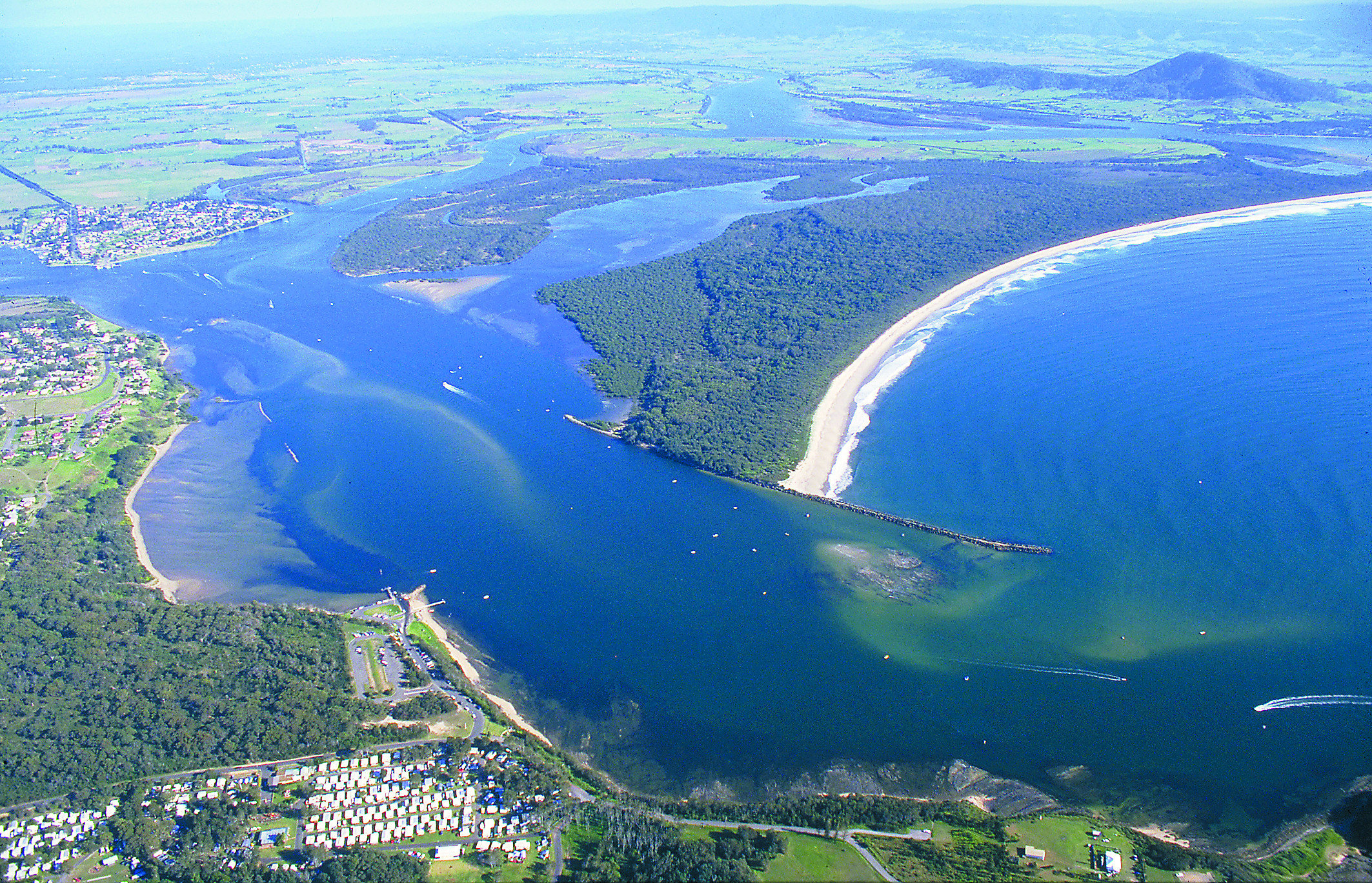
The river has two sea entrances, one permanently open to the south at Crookhaven Heads, a joint mouth of the Crookhaven and Shoalhaven Rivers, and the other intermittently open 5km to the north at Shoalhaven Heads.

The Shoalhaven River has most typical NSW estuary species, with bream, flathead and whiting the main catch, but also with luderick, mulloway, estuary perch and bass.

The river is shallow and usually clear and for this reason can be a challenging fishing location.

Winter sees a good run of luderick, with big flathead in summer.

Perch are often found near the deeper rock walls.

The Crookhaven mouth’s north shore bordering Comerong Island has good flats and weedbeds, with a rock wall that has landbased fishing, accessible via a ferry.

The inner wall has mainly luderick, while the outer wall has tailor, bream, flathead and mulloway.

The lower Crookhaven has dense mangrove areas bordering extensive flats which fish well for whiting, bream and flathead.

‘The Canal’ runs between Comerong Island and the southern mainland and is lined with rock walls.

The walls on the south bank have bream and luderick.

Local oyster racks produce good fish.

The rock walls at Greenwell Point, the wharves at Orient Point and the breakwall on Comerong Island are all good places for large bream, flathead and winter luderick.

At Nowra, the flats at the end of Pig Island have flathead, whiting and bream.

There is rocky reef between the island and the bridge, and navigating the north shore requires care, but the deep water next to it holds bream, luderick and mulloway.

The bridge pylons hold fish. Upstream of the bridge are rock walls with bream, flathead, whiting, mulloway and estuary perch.

The NSW Government installed an artificial reef 4.3km north-east of the Shoalhaven River entrance in 33m of water in January 2015, at 34 50.955S 150 47.731E (WGS84 datum).

There are 20 concrete modules in five clusters, five modules per cluster.

Kingfish, trevally, snapper, morwong, tailor, salmon and mulloway are the main catch, as well as baitfish.

To the north of Nowra the Gerringong area has good inshore boat fishing, with Werri Drift a proven flathead ground along Werri Beach, about 750m offshore.

Gravel Patch is 2.5km off the northern point of Werri Beach and has morwong and flathead.

The Crack in the Wall is almost 2km directly off Walkers Beach, with morwong and flathead.

There is broken reef between Black Head and Werri Point. The regions bass dams are Tallowa, Danjera and Flat Rock.

Stocked waters near Nowra include Danjera Dam, Flat Rock Dam and Tallowa Dam.

Great fishing can be had south of Nowra at the outstanding fishing location of Jervis Bay.

Nowra tides
Nowra region coastline
Shoalhaven artificial reef
NSW Govt Nowra fishing guide PDF
NSW Govt boating map PDF
Shoalhaven surf report with cam
NSW fishing regulations
NSW marine parks

Email corrections, additions, pictures or video here.

Moruya River, New South Wales

A NSW Government Moruya River boating map
A NSW Government Moruya River boating map. Click here to download the full PDF
Moruya River mouth ... the rock walls produce big fish. Picture John Lugg, NSW Govt
Moruya River mouth … the rock walls produce big fish. Picture John Lugg, NSW Govt

The Moruya River has 20km of tidal water, becoming Deua River and Burra Creek in the upper reaches.

The river is shallow, running mostly 2m to 3m deep, with many sandbanks and rocks upstream of the highway bridge.

Small-boat access is generally good except for 1km of river adjacent to the highway bridge.

Most fishing is done between the Moruya bridge and the sea entrance, an area that has fishable rock walls, weedbeds, flats and side creeks.

flathead and whiting are the drawcard on the Moruya and can be caught on lures or bait by drifting or casting.

Bream are also usually about, and the river has estuary perch and bass.

The Moruya River has good landbased access, with fishable rock walls on the northern and southern sides.

Bream, tailor, salmon, luderick and flathead are the main catch from the walls, with a chance of mulloway.

For boaters, the rock walls in the lower river are also the best place to fish for bream, tailor, trevally, mulloway, luderick, salmon, kingfish and flathead.

The lower river flats on the north side are the place for whiting and flathead. Try casting to the edges of weedbeds.

Quarry Wharf has mainly bream, flathead and tailor, while Preddys Wharf near Moruya Heads has bream, whiting, flathead, mullet, garfish, trevally and luderick.

Dolphin Beach and Pedro Point nearby have good beach fishing, with mainly flathead, bream and whiting. Beach worms are the best bait, but squid or prawns also work.

Shellys Beach is another good spot.

Moruya bridge pylons usually hold flathead, bream and luderick, with a chance of estuary perch.

The upper Moruya has bream and bass in winter.

As with all NSW rivers, heavy rain tends to push marine fish down the river, and mulloway may be feeding on flushed bait at the sea entrance after flooding.

Good boat fishing can be had in 50m-60m of water off Pedro Point and Congo. flathead, snapper, mulloway, kingfish, leatherjackets, tailor and salmon are caught.

Given a choice, most river fishos prefer to fish the nearby Tuross system, which is larger and hence has more fishing options, but nonetheless the Moruya is a great place to fish.

Moruya Heads tides
Moruya coastline
Moruya bar webcam
NSW fishing regulations
NSW marine parks

Email corrections, additions, pictures or video here.

Tuross, New South Wales

Tuross Lake ... a South Coast estuary fishing mecca. Picture John Lugg, NSW Govt
Tuross Lake … a South Coast estuary fishing mecca. Picture John Lugg, NSW Government
A NSW Government Tuross Lake boating map
Part of a NSW Government Tuross Lake boating map. Click here to download the full PDF

A vast expanse of shallow fishable estuaries surrounds Tuross.

These are Tuross Lake and Tuross Broadwater, with Coila Lake immediately to the north.

The vast estuary system forms the downstream section of Tuross River.

This area has been described as the gem of NSW’s South Coast.

Commercial fishing was banned locally in the 1980s.

The system is now productive for bream, tailor, salmon, luderick, flathead and whiting, as well as prawns.

The system of flats and channels runs to about 4m deep, with Tuross Head located north of the permanently open sea entrance.

The tidal limit in the Tuross River is at Comerang, 19km from the entrance, 9km upstream from the highway bridge, north of Bodalla.

Coila Lake, immediately north of Tuross, reaches 3m depth and usually has a closed entrance, but prawns and fish thrive.

The Tuross estuary is known for its trophy flathead, usually caught in spring, with fish 90cm and bigger taken. Special rules apply to these big fish.

The bigger sand whiting are usually caught near the river mouth.

The oyster racks are the best place to chase bream.

Upstream around Tuross Bridge and Snake Flat off Bumbo Road bass are caught. but these shallow waters are only suitable for cartopper or yak.

Coila Lake is famous for prawns, but it also has good bream.

The main boat ramp for the Tuross system is at Lavender Bay near the river mouth, with a second at the Tuross Bridge on the Princes Highway, 6km south of the
Tuross Head turnoff.

This second boat ramp is used to access the estuaries to the west of Tuross Bridge.

Coila Lake has two boat ramps, the first at Kyla Sporting Complex and the second at the end of Foam Street.

Tuross tides
Tuross coastline
NSW fishing regulations
NSW marine parks

Email corrections, additions, pictures or video here.