Turkey Beach is a charming holiday community located east-south-east of Gladstone.
It is nestled beside Rodd’s Harbour, a vast estuary where Oyster Creek and Oakey Creek converge.
To the west of Turkey Beach lies the Seven Mile Creek estuary, while Pancake Creek is situated to the east. These expansive estuaries are shaped by significant tidal movements.
Although the estuaries around Rodd’s Harbour can be reached by trailer boat from Gladstone (approximately 22nm in favorable weather), towing a boat by road is a safer option.
Offshore, Rodd’s Peninsula is home to Clew Point’s outermost rocks, renowned as one of the East Coast’s prime Spanish mackerel fishing spots during winter.
In the estuaries, highlights include big threadfin salmon, mud crabs, bream, fingermark, mangrove jacks, and the occasional barramundi.
Spotted and grey mackerel frequent the bays in season, typically around August. Reef fish can also be found near scattered reef and coral areas.
Yabbies (nippers) are abundant and serve as excellent bait for whiting on the flats and tuskfish on the reefs.
Boating options include launching from Turkey Beach’s concrete ramp or the Pancake Creek causeway, which requires sufficient tidal levels. Note that tidal currents affect both ramps, and some boaters prefer launching beside the Turkey Beach ramp.
Pancake Creek offers exceptional whiting and flathead fishing and serves as a safe anchorage.
For a more adventurous option, boats can be launched from Sandy Creek, about 12km south-west of Turkey Beach. This location, accessible via Dyckhoffs Road (also signposted as Jinkies Landing), is suitable at higher tides. Camping is not permitted, and gates should be left as found.
Kinchant is one of three stocked dams in Mackay, known for producing some of the fattest barramundi in Queensland.
It became the first dam in the state to have artificial reefs installed in June 2019.
Constructed on the Pioneer River in 1977, Kinchant is located 30km west of Mackay.
The dam spans 920 hectares, with an average depth of 7m.
Kinchant Dam supports a variety of fish species, including barramundi, sleepy cod, sooty grunter, eel-tail catfish, fork-tail catfish, spangled perch, and mouth almighty. Barramundi were introduced in 2000 and have flourished, resulting in massive catches. Stocking is managed by the Mackay Area Fish Stocking Association, which added 4660 barramundi in 2017/18, with a total of 146,000 barramundi stocked to date.
There are no vessel restrictions on Kinchant, making it popular for watersports, though serious anglers may prefer to visit during weekdays to avoid the crowds.
Accommodation is available at the Kinchant Waters campground, offering self-contained cabins, van and tent sites. Facilities include toilets, barbecues, picnic tables, shelters, a cafe, a licensed bar and restaurant, and a pool table. Outdoor enthusiasts can also enjoy walking and mountain-biking trails.
How to Fish Kinchant Dam
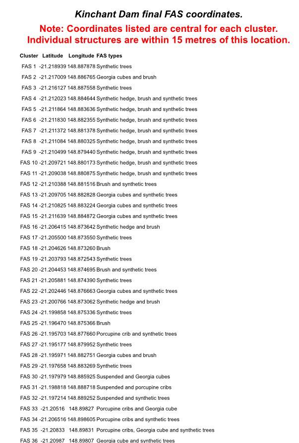
Try trolling or jigging over the structures shown in these GPS co-ordinates
Before the installation of artificial reefs (shown in the GPS coordinates above), Kinchant had minimal structure. Anglers primarily fished the weedbeds, shoreline, and the long rock wall. Now, the artificial reefs offer excellent opportunities for trolling and jigging.
For successful fishing:
– Use sonar to locate the reefs.
– Target weedy points, baitfish balls, and areas near barramundi activity.
– Observe feeding birds to locate active fish.
Barramundi fishing is available year-round, but warmer months yield better results. Kinchant’s barramundi are notoriously wary, so smaller lures often perform best. Night fishing can also be highly effective.
Given the shallow water, quietly approach fishing spots using an electric motor or oars. While lighter tackle is generally sufficient, some hooked barramundi may be too large to land.
Mackay’s other stocked dams, Teemburra and Eungella, are more scenic, but Kinchant remains unparalleled for its record-sized fish.