Clairview gives access to the shallow waters of upper Broad Sound, the large Clairview Creek and several smaller tidal creeks.
Launching is at the foreshore ramp at Clairview’s BarraCrab Caravan Park, travelling 9km south by sea and going in through the creek mouth.
Boaters launch at the ramp near the van park on the incoming tide, fish the high and early outgoing tide, and return when there is enough water to retrieve the boat.
This area is subject to huge tides and there is large tidal mudflat, so trips must be planned accordingly.
The bigger tides can create rough conditions when wind and tidal currents are opposed.
Smaller tides bring clearer water, especially after the neap cycle.
Smaller creeks in the area have launch sites suitable for small boats.
Clairview Creek, 10km south of Clairview, is the major local waterway.
The creek has jewfish, grunter, salmon, golden snapper, mangrove jacks and barra.
The smaller ‘Oyster Creek’, 5km south of Clairview Creek, fishes well but has a substantial rockbar that restricts upper access.
There are oyster rocks in both creeks, and holes which hold jewfish and barramundi.
Flock Pigeon Island is just 4km from the van park ramp and the reef at south end has golden snapper, cod and salmon.
Red Clay Island, 30km out, has coral trout and other reef fish, including pink snapper.
Most estuary fish are available all year, with threadfin salmon best in winter.
Big salmon are caught from the beach near Clairview, as well as whiting and flathead.
The Clairview area is quite sheltered and seems less windy than Mackay, says van park owner Bill Frier.
Stanage township and the labyrinth of nearby creeks and channels around Thirsty Sound are located at the end of a peninsula that separates Broad Sound and Shoalwater Bay.
This is a fascinating and highly productive area for fishos.
This region is about as remote as it gets on Queensland’s central east coast, with a great mix of estuary and bluewater fishing.
Stanage is a tiny holiday town that has a good boat ramp and basic facilities nearby.
The sign-posted turn-off is about 75km north of Rockhampton on the Bruce Hwy.
The unsealed Stanage road is 100km long and scares off many people, but is usually well maintained.
Fishermen can start at Porters Creek at Stanage, reached by a short track from the boat ramp. The ramp is useable from about half tide up.
This is a great spot to collect mullet and yabbies for bait, and there is free camping at the creek.
Thirsty Sound, between Broad Sound and Shoalwater Bay, is a mostly shallow body of water inside Quail and Long Islands.
The whole area is affected by strong currents.
Thirsty Sound enters the shallow expanse of Broad Sound to the west.
Expect to catch barramundi and huge mud crabs throughout the estuaries.
Large local tides mean crab pots must be tied to mangroves or they might wash away.
Jewfish are best Oct/March, salmon and mackerel from June/Sept, and barra from Feb/Nov, with winter months preferred.
Stanage is the gateway to countless islands and reefs offshore with fishing for tropical and southern species.
Reef fishing is all year.
Big male crabs are common around Stanage from Dec/July.
Care is required navigating Thirsty Sound as it dries in places.
The great tidal run and shallow water ensures a chop if wind and tide are opposed, and dinghy users must take care.
There is plenty of beach and rock fishing near the township, with threadfin salmon and bream the main catch.
Prawns are in the gutters off Long Island from Dec/Feb.
Three rockbars in the area can not be crossed from half-tide down, for more information get a copy of the North Australian FISH FINDER book.
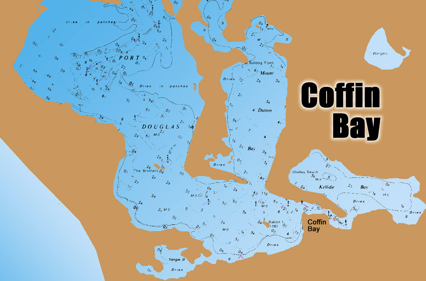
Coffin Bay is one of South Australia’s great fishing locations.
The area has sheltered tidal areas ideal for trailerboaters and yakkers, with deep offshore reefs accessible to those with bigger boats, along with several islands.
There are surf beaches and other landbased spots to the north and south.
The fishable area is huge, with good boating facilities at the township despite it being inhabited by fewer than 1000 permanent residents.
The offshore waters offer exciting fishing for tuna, samson, kingfish, snapper, morwong, nannygai and more.
Most holiday fishos target the inshore waters, with king george whiting the main species sought.
The KGs are usually found on the edges of weedbeds out of the main current of the deeper channel areas.
One of the best whiting areas is out of Farm Beach, at the Coffin Bay entrance.
To reach this area skippers can beach-launch at Farm Beach, or make a 15km run from the town ramp.
Whiting can be caught from shore at times. The boat ramp area, and the ledge opposite the township, are as good as anywhere, and the shoreline at Mt Dutton Bay.
Winter is arguably the best time for chasing whiting.
Garfish and tommy ruff respond well to berley in summer.
A highlight of the area is a spring run of big yellowtail kingfish that move into shallow Kellidie Bay.
These fish can be targeted in small boats and sight fishing is possible, one of the state’s fishing highlights.
Snapper are caught within the bay in the channel and other deeper spots, but the water is very clear and light tackle and fresh bait is a must. Fishing at night improves your chances.
The Coffin Bay peninsula is 40km in length but conventional vehicles can only go as far as Yangi Bay. From there you need 4WD and sand driving ability.
On the western side of the peninsula Gunyah and Almonta Beaches produce salmon. The sand is soft, so take a compressor and deflate your tyres. Winter fishing is best, but summer produces salmon at times.
The east side of the peninsula has small beaches and points that produce whiting, garfish, silver trevally and small salmon. Try Black Springs, Seasick Bay and Point Sir Issacs.
There are several campgrounds in the national park.
The coast between Point Sir Isaacs and Whidbey Point is not accessible by vehicle but can be reached by fit fishos on foot. The rocks produce better-than-usual fish, including whiting, sweep, nannygai, blue groper and snapper.
From February to April, tuna feed near Point Whidbey.
Outside the bay, for those with suitable boats, and a window in the weather, nannygai, morwong and snapper are caught on the deeper reefs near Sir Isaacs and north to Coles Point. Most of the reefs are to 35m depth.
Out wider, from January to April, southern bluefin tuna are caught. The schools start from around Whidbey Point, buty the best grounds are around Four Hummocks, Greenly Island and Rocky Island. Expect fish of 10kg to 20kg. .
The deep reefs around Greenly Island have kingfish and samson but rarely produce snapper. These reefs rise from 80m to about 40m.
For families, fishing the Coffin Bay shallows for silver trevally, flathead, snook, squid and flounder is fun and offers relative safety.
For those with 4WD vehicles, beach launching is possible at the southern end of Avoid Bay.
North of Coffin Bay there is rock and surf fishing at Coles Point, Greenly Beach, Convention Beach and Drummond Point.
Coffin Bay is famous for its oysters, and finding a feed of southern rock lobster is usually easy enough when the weather is suitable.
Beware breaking waves around shallow reefs when fishing outside of the sheltered waters.
A series of markers provide boaters with the best path to navigate in and out of the Coffin Bay “port”.
If there is a downside to fishing this region, it is that – if you are bait fishing – you will be pestered by endless rays and crabs.
A reminder that special snapper rules apply in SA, and new restrictions were announced following a destructive marine algal bloom ... view details here.